Home > Europe > United Kingdom > England > London > Royalty
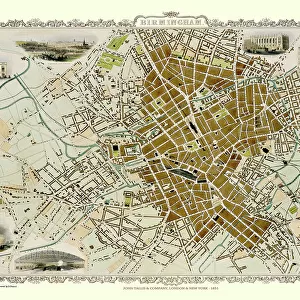
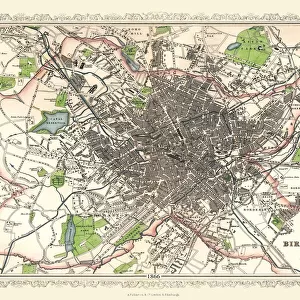
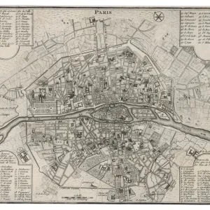
Old Map of Birmingham 1898 from the Royal Atlas by Bartholomew

![]()
Wall Art and Photo Gifts from MapSeeker
Old Map of Birmingham 1898 from the Royal Atlas by Bartholomew
A fine very detailed plan of the City of Birmingham remastered from an original contained within " The Royal Atlas of England and Wales" ; edited by J.G. Bartholomew, published by George Newnes, Limited, London
Welcome to the Mapseeker Image library and enter an historic gateway to one of the largest on-line collections of Historic Maps, Nostalgic Views, Vista's and Panorama's from a World gone by.
Media ID 20347614
Bartholomew Bartholomew Map Birmingham Birmingham City Birmingham Map Birmingham Town Plan Historic Birmingham Map Historic Map Map Of Birmingham Old Map Of Birmingham Old Town Plan Royal Atlas Royal Atlas Map
FEATURES IN THESE COLLECTIONS
> Arts
> Photorealistic artworks
> Detailed art pieces
> Masterful detailing in art
> Europe
> United Kingdom
> England
> Birmingham
> Related Images
> Europe
> United Kingdom
> England
> London
> Royalty
> Europe
> United Kingdom
> England
> Maps
> Europe
> United Kingdom
> Wales
> Maps
> Europe
> United Kingdom
> Wales
> Posters
> Maps and Charts
> Related Images
> Maps and Charts
> Wales
> MapSeeker
> British Town And City Plans
> English & Welsh PORTFOLIO
EDITORS COMMENTS
This stunning print showcases an exquisite piece of history - the Old Map of Birmingham from 1898. Remastered from the original found within "The Royal Atlas of England and Wales" this fine and highly detailed plan offers a captivating glimpse into the City of Birmingham's past. Edited by J. G. Bartholomew and published by George Newnes, Limited in London, this map is a true treasure. With its intricate cartography and meticulous attention to detail, this old town plan provides a fascinating insight into the layout and development of Birmingham during that era. Every street, building, park, and landmark is meticulously depicted, allowing us to trace the city's evolution over time. As we gaze upon this historic map, we are transported back to a bygone era when horse-drawn carriages traversed cobblestone streets lined with charming Victorian architecture. We can almost hear the bustling sounds of market traders hawking their wares or catch glimpses of locals going about their daily lives. Whether you are a history enthusiast or simply captivated by maps, this print is sure to ignite your imagination as you explore every corner of old Birmingham through its beautifully preserved details. A testament to both artistry and historical significance, it serves as a reminder that our cities have deep roots worth cherishing for generations to come.
MADE IN AUSTRALIA
Safe Shipping with 30 Day Money Back Guarantee
FREE PERSONALISATION*
We are proud to offer a range of customisation features including Personalised Captions, Color Filters and Picture Zoom Tools
SECURE PAYMENTS
We happily accept a wide range of payment options so you can pay for the things you need in the way that is most convenient for you
* Options may vary by product and licensing agreement. Zoomed Pictures can be adjusted in the Cart.