Home > Maps and Charts > Related Images
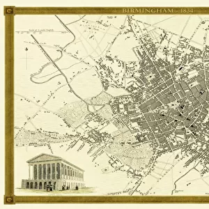
Old Map of Birmingham Surveyed in 1750 by Thomas Hanson

![]()
Wall Art and Photo Gifts from MapSeeker
Old Map of Birmingham Surveyed in 1750 by Thomas Hanson
J071
Welcome to the Mapseeker Image library and enter an historic gateway to one of the largest on-line collections of Historic Maps, Nostalgic Views, Vista's and Panorama's from a World gone by.
Media ID 20347084
Birmingham Birmingham City Birmingham City Map Birmingham Map Birmingham Town Plan Historic Birmingham Map Historic Map Map Of Birmingham Old Map Of Birmingham Old Town Plan Town Plan Of Birmingham Hanson
FEATURES IN THESE COLLECTIONS
> Maps and Charts
> Related Images
> MapSeeker
> British Town And City Plans
> English & Welsh PORTFOLIO
EDITORS COMMENTS
This print showcases an exquisite piece of history, the "Old Map of Birmingham Surveyed in 1750" by the talented cartographer Thomas Hanson (J071). Stepping back in time, this remarkable map offers a glimpse into the early days of Birmingham's development. With intricate details and precision, Hanson meticulously captured the essence of this bustling city during its formative years. As we explore this vintage treasure, we are transported to a bygone era when Birmingham was just beginning to emerge as an industrial powerhouse. The town plan depicted on this map reveals a network of narrow streets lined with charming buildings and landmarks that have since evolved or vanished altogether. It is fascinating to witness how the city has transformed over centuries. The historic significance of this map cannot be overstated; it serves as a testament to Birmingham's rich heritage and provides valuable insights into its urban evolution. Whether you are a history enthusiast or simply curious about your hometown's roots, this old map will undoubtedly captivate your imagination
MADE IN AUSTRALIA
Safe Shipping with 30 Day Money Back Guarantee
FREE PERSONALISATION*
We are proud to offer a range of customisation features including Personalised Captions, Color Filters and Picture Zoom Tools
SECURE PAYMENTS
We happily accept a wide range of payment options so you can pay for the things you need in the way that is most convenient for you
* Options may vary by product and licensing agreement. Zoomed Pictures can be adjusted in the Cart.