Home > Europe > United Kingdom > Scotland > Fife > Falkland
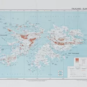
Old Map of Falkland Islands and Patagonia 1851 by John Tallis

![]()
Wall Art and Photo Gifts from MapSeeker
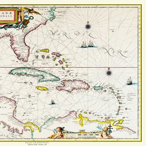
Old Map of Falkland Islands and Patagonia 1851 by John Tallis
A fine facimile artworked from an antique original map of the Falkland Islands and Patagonia, issued as part of the 1851 edition of John Tallis and Companys " The Illustrated Atlas and Modern History of the World"
Welcome to the Mapseeker Image library and enter an historic gateway to one of the largest on-line collections of Historic Maps, Nostalgic Views, Vista's and Panorama's from a World gone by.
Media ID 20347676
© Mapseeker Publishing Ltd
John Tallis John Tallis Map Tallis Map Falklands
FEATURES IN THESE COLLECTIONS
> Arts
> Artists
> T
> John Tallis
> Europe
> United Kingdom
> Scotland
> Fife
> Falkland
> Maps and Charts
> Related Images
> Maps and Charts
> World
> MapSeeker
> Maps of the Americas
> Maps of Central and South America
> South America
> Falkland Islands
> Maps
> South America
> Falkland Islands
> Related Images
EDITORS COMMENTS
This print showcases an exquisite piece of cartographic history - the "Old Map of Falkland Islands and Patagonia 1851" by John Tallis. Crafted with utmost precision and attention to detail, this fine facsimile artwork faithfully reproduces an antique original map that was part of the renowned 1851 edition of John Tallis and Company's "The Illustrated Atlas and Modern History of the World". Transporting us back in time, this map offers a glimpse into the past, revealing the intricate geography and fascinating landmarks of Falkland Islands and Patagonia as they were known in the mid-19th century. Every contour line, river course, mountain range, and coastal feature has been meticulously rendered to provide an accurate representation. John Tallis, a distinguished cartographer of his era, collaborated with talented artist John Rapkin to create this masterpiece. Their combined expertise is evident in every stroke on this remarkable map. The delicate color palette adds depth to its visual appeal while enhancing our understanding of geographical nuances. Whether you are a history enthusiast or simply captivated by vintage maps, this print will undoubtedly become a cherished addition to your collection. It serves as both a testament to human curiosity about our world's landscapes throughout centuries gone by and a reminder that even amidst technological advancements today, there is still immense value in preserving these timeless works for future generations.
MADE IN AUSTRALIA
Safe Shipping with 30 Day Money Back Guarantee
FREE PERSONALISATION*
We are proud to offer a range of customisation features including Personalised Captions, Color Filters and Picture Zoom Tools
SECURE PAYMENTS
We happily accept a wide range of payment options so you can pay for the things you need in the way that is most convenient for you
* Options may vary by product and licensing agreement. Zoomed Pictures can be adjusted in the Cart.