Home > Arts > Artists > S > John Speed
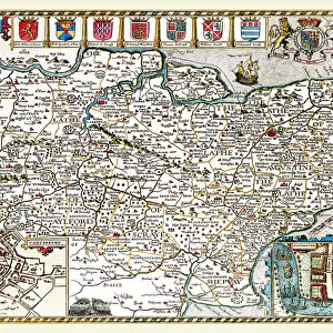
Old County Map of Cambridgeshire 1611 by John Speed

![]()
Wall Art and Photo Gifts from MapSeeker
Old County Map of Cambridgeshire 1611 by John Speed
A facimile of John Speeds historical map of Cambridgeshire originally published for the " Theatre of the Empire of Great Britain", an atlas to accompany " a history of Great Britain"
Welcome to the Mapseeker Image library and enter an historic gateway to one of the largest on-line collections of Historic Maps, Nostalgic Views, Vista's and Panorama's from a World gone by.
Media ID 20347753
© Mapseeker Publishing Ltd
County Map County Map Of England English County Map Historic Map John Speed Map Old County Map Old English County Map Speed Map Speede Map Cambridgeshire
FEATURES IN THESE COLLECTIONS
> Arts
> Artists
> S
> John Speed
> Europe
> United Kingdom
> England
> Cambridgeshire
> Related Images
> Europe
> United Kingdom
> England
> Maps
> Maps and Charts
> British Empire Maps
> Maps and Charts
> Early Maps
> Maps and Charts
> Related Images
> MapSeeker
> Maps from the British Isles
> England and Counties PORTFOLIO
EDITORS COMMENTS
This exquisite print showcases the "Old County Map of Cambridgeshire 1611" by John Speed, a renowned cartographer of his time. Originally published for the "Theatre of the Empire of Great Britain" an atlas accompanying a comprehensive history of Great Britain, this facsimile offers us a glimpse into the rich historical heritage of Cambridgeshire. With its intricate details and elegant design, this map takes us back to a bygone era when hand-drawn maps were treasured works of art. The meticulous craftsmanship is evident in every stroke as Speed captures the essence and topography of Cambridgeshire with remarkable accuracy. As we explore this historic map, we are transported to a time when boundaries were defined differently, and settlements had yet to evolve into bustling cities. It allows us to trace the winding rivers that meander through picturesque landscapes and discover quaint villages nestled amidst rolling hills. This piece serves as more than just a visual representation; it is an invitation to delve into centuries-old stories that have shaped this county's identity. From ancient landmarks like Ely Cathedral to notable towns such as Cambridge itself, each place on this map holds significance in Cambridgeshire's past. Whether you are an avid historian or simply appreciate fine artistry, this print brings together beauty and historical value seamlessly. Display it proudly in your home or office space as a testament to both John Speed's skillful cartography and Cambridgeshire's enduring legacy.
MADE IN AUSTRALIA
Safe Shipping with 30 Day Money Back Guarantee
FREE PERSONALISATION*
We are proud to offer a range of customisation features including Personalised Captions, Color Filters and Picture Zoom Tools
SECURE PAYMENTS
We happily accept a wide range of payment options so you can pay for the things you need in the way that is most convenient for you
* Options may vary by product and licensing agreement. Zoomed Pictures can be adjusted in the Cart.