Home > Europe > United Kingdom > England > Huntingdonshire
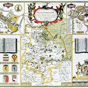
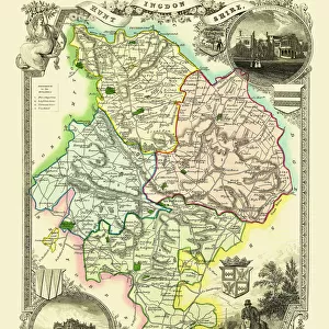
Old County Map of Huntingdonshire 1611 by John Speed

![]()
Wall Art and Photo Gifts from MapSeeker
Old County Map of Huntingdonshire 1611 by John Speed
A facimile of John Speeds historical map of Huntingdonshire originally published for the " Theatre of the Empire of Great Britain", an atlas to accompany " a history of Great Britain"
Welcome to the Mapseeker Image library and enter an historic gateway to one of the largest on-line collections of Historic Maps, Nostalgic Views, Vista's and Panorama's from a World gone by.
Media ID 20347548
© Mapseeker Publishing Ltd
County Map County Map Of England English County Map Historic Map John Speed Map Old County Map Old English County Map Speed Map Speede Map Huntingdonshire
FEATURES IN THESE COLLECTIONS
> Arts
> Artists
> S
> John Speed
> Europe
> United Kingdom
> England
> Huntingdonshire
> Europe
> United Kingdom
> England
> Maps
> Maps and Charts
> British Empire Maps
> Maps and Charts
> Early Maps
> Maps and Charts
> Related Images
> MapSeeker
> Maps from the British Isles
> England and Counties PORTFOLIO
EDITORS COMMENTS
This print showcases the "Old County Map of Huntingdonshire 1611" by John Speed, a renowned cartographer from the 17th century. Originally published for the "Theatre of the Empire of Great Britain" an atlas accompanying a comprehensive history of Great Britain, this facsimile offers us a glimpse into the rich historical tapestry of Huntingdonshire. With its intricate details and exquisite craftsmanship, this English county map takes us back in time to explore the region as it was over four centuries ago. The map reveals not only geographical features but also provides insights into political boundaries and settlements during that era. John Speed's expertise is evident in his meticulous rendering of every town, village, river, and road within Huntingdonshire. This historic map serves as both an educational tool for historians and a beautiful piece of art for enthusiasts who appreciate cartographic masterpieces. As we delve into this fascinating snapshot from history, we can imagine how life must have unfolded in Huntingdonshire during those times. It reminds us that beneath our modern landscape lies layers upon layers of stories waiting to be discovered. Whether you are an avid collector or simply intrigued by historical maps, this old county map is sure to captivate your imagination and transport you to a bygone era filled with exploration and adventure.
MADE IN AUSTRALIA
Safe Shipping with 30 Day Money Back Guarantee
FREE PERSONALISATION*
We are proud to offer a range of customisation features including Personalised Captions, Color Filters and Picture Zoom Tools
SECURE PAYMENTS
We happily accept a wide range of payment options so you can pay for the things you need in the way that is most convenient for you
* Options may vary by product and licensing agreement. Zoomed Pictures can be adjusted in the Cart.