Home > Europe > United Kingdom > England > London > Towns > Welling
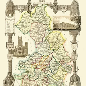
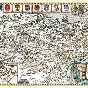
Old County Map of Huntingdonshire 1836 by Thomas Moule

![]()
Wall Art and Photo Gifts from MapSeeker
Old County Map of Huntingdonshire 1836 by Thomas Moule
This is a fine decorative reproduction County Map of Huntingdonshire from the First Edition series of Thomas Moule Maps, originally Published in 1836. The well-known series of County Maps which are known as Moules feature beautiful vignette views and were first published in separate sections for each county in 1830-32, they were then published in collected form in a two-volume work: The English Counties Delineated: or a Topographical Description of England: Illustrated by a Complete Series of County Maps by Thomas Moule: London: Published by George Virtue 1836
Welcome to the Mapseeker Image library and enter an historic gateway to one of the largest on-line collections of Historic Maps, Nostalgic Views, Vista's and Panorama's from a World gone by.
Media ID 20347487
© Mapseeker Publishing Ltd
County Map County Map Of England English County Map Historic Map Moule Map Old County Map Old English County Map Old Moule Map Thomas Moule Thomas Moule Map Huntingdonshire
FEATURES IN THESE COLLECTIONS
> Arts
> Artists
> M
> Thomas Moule
> Europe
> United Kingdom
> England
> Huntingdonshire
> Europe
> United Kingdom
> England
> London
> Towns
> Welling
> Europe
> United Kingdom
> England
> Maps
> Europe
> United Kingdom
> England
> Wells
> Maps and Charts
> Early Maps
> Maps and Charts
> Related Images
> MapSeeker
> Maps from the British Isles
> England and Counties PORTFOLIO
EDITORS COMMENTS
This exquisite print showcases the "Old County Map of Huntingdonshire 1836" by Thomas Moule, a renowned cartographer from the 19th century. Originally published as part of Moule's First Edition series in 1836, this decorative reproduction captures the charm and historical significance of the original map. Moule's County Maps are highly regarded for their intricate details and captivating vignette views. Each county was meticulously depicted in separate sections between 1830 and 1832 before being compiled into a comprehensive two-volume work titled "The English Counties Delineated: or a Topographical Description of England". This particular map is featured within that collection, published by George Virtue in London in 1836. As an old English county map, it offers a fascinating glimpse into Huntingdonshire's past. Its rich historical value makes it an ideal addition to any collection or display focused on British history. The fine craftsmanship evident in every line and illustration transports viewers back to a time when maps were not just navigational tools but also works of art. With its detailed depiction of Huntingdonshire's landscape and landmarks, this historic map serves as both an educational resource and a visual delight. Whether you're interested in exploring your ancestral roots or simply appreciating the beauty of vintage cartography, this print allows you to bring home a piece of history created by one of England's most esteemed cartographers – Thomas Moule – with publishing support from George Virtue.
MADE IN AUSTRALIA
Safe Shipping with 30 Day Money Back Guarantee
FREE PERSONALISATION*
We are proud to offer a range of customisation features including Personalised Captions, Color Filters and Picture Zoom Tools
SECURE PAYMENTS
We happily accept a wide range of payment options so you can pay for the things you need in the way that is most convenient for you
* Options may vary by product and licensing agreement. Zoomed Pictures can be adjusted in the Cart.