Home > Arts > Artists > S > John Speed
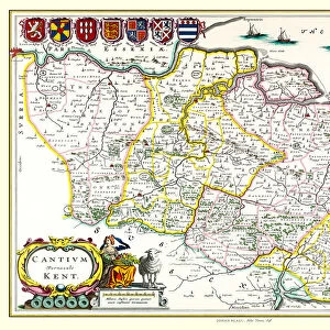
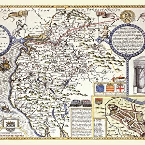
Old County Map of Kent 1611 by John Speed

![]()
Wall Art and Photo Gifts from MapSeeker
Old County Map of Kent 1611 by John Speed
A facimile of John Speeds historical map of Kent originally published for the " Theatre of the Empire of Great Britain", an atlas to accompany " a history of Great Britain"
Welcome to the Mapseeker Image library and enter an historic gateway to one of the largest on-line collections of Historic Maps, Nostalgic Views, Vista's and Panorama's from a World gone by.
Media ID 20348170
© Mapseeker Publishing Ltd
County Map County Map Of England English County Map Historic Map John Speed Map Old County Map Old English County Map Speed Map Speede Map
FEATURES IN THESE COLLECTIONS
> Arts
> Artists
> S
> John Speed
> Europe
> United Kingdom
> England
> Kent
> Related Images
> Europe
> United Kingdom
> England
> Maps
> Maps and Charts
> British Empire Maps
> Maps and Charts
> Early Maps
> Maps and Charts
> Related Images
> MapSeeker
> Maps from the British Isles
> England and Counties PORTFOLIO
EDITORS COMMENTS
This stunning print showcases the "Old County Map of Kent 1611" by John Speed, a renowned cartographer of his time. Originally published for the "Theatre of the Empire of Great Britain" an atlas accompanying a comprehensive history of Great Britain, this facsimile captures the intricate details and historical significance of Speed's work. With its rich colors and exquisite craftsmanship, this old English county map takes us back in time to explore the enchanting landscapes and hidden treasures that once defined Kent. Every line and symbol on this map tells a story, revealing ancient towns, winding rivers, majestic castles, and sprawling estates that have shaped the region's identity over centuries. John Speed's meticulous attention to detail is evident as he meticulously charts every road, village, and landmark with precision. This historic map not only serves as a valuable resource for historians but also captivates anyone with an appreciation for artistry and heritage. As we gaze upon this piece, we are transported to an era where exploration was at its peak. The Old County Map of Kent allows us to reimagine how life unfolded in these picturesque lands long before our time. It invites us to embark on a visual journey through history while igniting our curiosity about what lies beyond those faded borders. Whether you're an avid collector or simply fascinated by maps' power to connect past and present generations alike, this print is sure to be a cherished addition to your collection. Let it serve as a reminder that even within static lines lies
MADE IN AUSTRALIA
Safe Shipping with 30 Day Money Back Guarantee
FREE PERSONALISATION*
We are proud to offer a range of customisation features including Personalised Captions, Color Filters and Picture Zoom Tools
SECURE PAYMENTS
We happily accept a wide range of payment options so you can pay for the things you need in the way that is most convenient for you
* Options may vary by product and licensing agreement. Zoomed Pictures can be adjusted in the Cart.