Home > Europe > United Kingdom > England > London > Towns > Welling
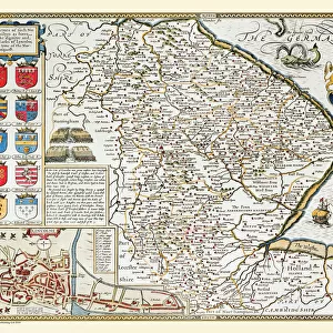
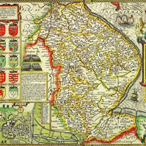
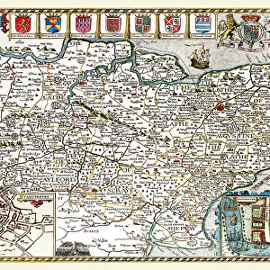
Old County Map of Lincolnshire 1836 by Thomas Moule

![]()
Wall Art and Photo Gifts from MapSeeker
Old County Map of Lincolnshire 1836 by Thomas Moule
This is a fine decorative reproduction County Map of Lincolnshire from the First Edition series of Thomas Moule Maps, originally Published in 1836. The well-known series of County Maps which are known as Moules feature beautiful vignette views and were first published in separate sections for each county in 1830-32, they were then published in collected form in a two-volume work: The English Counties Delineated: or a Topographical Description of England: Illustrated by a Complete Series of County Maps by Thomas Moule: London: Published by George Virtue 1836
Welcome to the Mapseeker Image library and enter an historic gateway to one of the largest on-line collections of Historic Maps, Nostalgic Views, Vista's and Panorama's from a World gone by.
Media ID 20347911
© Mapseeker Publishing Ltd
County Map County Map Of England English County Map Historic Map Moule Map Old County Map Old English County Map Old Moule Map Thomas Moule Thomas Moule Map Lincolnshire
FEATURES IN THESE COLLECTIONS
> Arts
> Artists
> M
> Thomas Moule
> Europe
> United Kingdom
> England
> Lincolnshire
> Related Images
> Europe
> United Kingdom
> England
> Lincolnshire
> Well
> Europe
> United Kingdom
> England
> London
> Towns
> Welling
> Europe
> United Kingdom
> England
> Maps
> Europe
> United Kingdom
> England
> Wells
> Maps and Charts
> Early Maps
> Maps and Charts
> Related Images
> MapSeeker
> Maps from the British Isles
> England and Counties PORTFOLIO
EDITORS COMMENTS
This exquisite print showcases the "Old County Map of Lincolnshire 1836" by Thomas Moule, a renowned cartographer of his time. Originally published as part of Moule's First Edition series in 1836, this decorative reproduction offers a glimpse into the rich history and topography of Lincolnshire. Moule's County Maps are widely recognized for their intricate details and captivating vignette views. Each county was meticulously depicted in separate sections between 1830 and 1832 before being compiled into a comprehensive two-volume work titled "The English Counties Delineated: or a Topographical Description of England". This particular map is an authentic representation from that collection, published by George Virtue in London. With its aged charm and historical significance, this old English county map serves as more than just a geographical reference. It transports us back to the early nineteenth century when these maps were treasured possessions, offering valuable insights into the landscapes and landmarks that shaped our past. Whether you're an avid collector of historic maps or simply captivated by Lincolnshire's heritage, this Thomas Moule masterpiece is sure to be cherished. Hang it proudly on your wall as a testament to both artistry and history—a window into the enchanting world captured within its borders.
MADE IN AUSTRALIA
Safe Shipping with 30 Day Money Back Guarantee
FREE PERSONALISATION*
We are proud to offer a range of customisation features including Personalised Captions, Color Filters and Picture Zoom Tools
SECURE PAYMENTS
We happily accept a wide range of payment options so you can pay for the things you need in the way that is most convenient for you
* Options may vary by product and licensing agreement. Zoomed Pictures can be adjusted in the Cart.