Home > Arts > Artists > S > John Speed
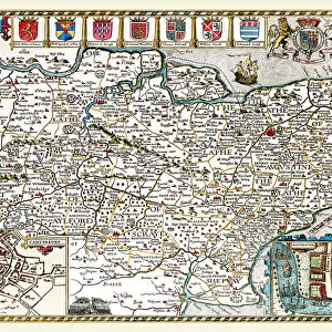
Old County Map of Nottinghamshire 1611 by John Speed

![]()
Wall Art and Photo Gifts from MapSeeker
Old County Map of Nottinghamshire 1611 by John Speed
A facimile of John Speeds historical map of Nottinghamshire originally published for the " Theatre of the Empire of Great Britain", an atlas to accompany " a history of Great Britain"
Welcome to the Mapseeker Image library and enter an historic gateway to one of the largest on-line collections of Historic Maps, Nostalgic Views, Vista's and Panorama's from a World gone by.
Media ID 20347568
© Mapseeker Publishing Ltd
County Map County Map Of England English County Map Historic Map John Speed Map Old County Map Old English County Map Speed Map Speede Map Nottinghamshire
FEATURES IN THESE COLLECTIONS
> Arts
> Artists
> S
> John Speed
> Europe
> United Kingdom
> England
> Maps
> Europe
> United Kingdom
> England
> Nottinghamshire
> Related Images
> Maps and Charts
> British Empire Maps
> Maps and Charts
> Early Maps
> Maps and Charts
> Related Images
> MapSeeker
> Maps from the British Isles
> England and Counties PORTFOLIO
EDITORS COMMENTS
This print showcases the "Old County Map of Nottinghamshire 1611" by the renowned cartographer John Speed. Originally published as part of his esteemed work, "The Theatre of the Empire of Great Britain" this facsimile edition allows us to delve into the rich history and intricate details of Nottinghamshire's past. As we gaze upon this old English county map, we are transported back in time to a period when maps were meticulously hand-drawn and served as invaluable tools for exploration and understanding. Every stroke on this historic map tells a story, revealing the boundaries, towns, villages, rivers, and landmarks that shaped Nottinghamshire centuries ago. John Speed's expertise is evident in every inch of this masterpiece. His attention to detail brings life to each corner of the county, allowing us to imagine how it once looked during an era long gone. This historical gem not only serves as a visual delight but also provides valuable insights into England's geography and its evolution over time. Whether you are a history enthusiast or simply intrigued by cartography, this print offers an opportunity to appreciate John Speed's remarkable contribution to our understanding of Great Britain's past. Let your imagination soar as you explore Nottinghamshire through the eyes of one of history's greatest mapmakers – truly a treasure for any admirer of historical maps!
MADE IN AUSTRALIA
Safe Shipping with 30 Day Money Back Guarantee
FREE PERSONALISATION*
We are proud to offer a range of customisation features including Personalised Captions, Color Filters and Picture Zoom Tools
SECURE PAYMENTS
We happily accept a wide range of payment options so you can pay for the things you need in the way that is most convenient for you
* Options may vary by product and licensing agreement. Zoomed Pictures can be adjusted in the Cart.