Home > Arts > Artists > S > John Speed
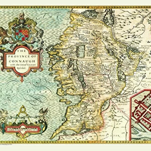
Old Map of Ireland 1611 by John Speed

![]()
Wall Art and Photo Gifts from MapSeeker
Old Map of Ireland 1611 by John Speed
A facimile of John Speeds historical map of Ireland originally published for the " Theatre of the Empire of Great Britain", an atlas to accompany " a history of Great Britain"
Welcome to the Mapseeker Image library and enter an historic gateway to one of the largest on-line collections of Historic Maps, Nostalgic Views, Vista's and Panorama's from a World gone by.
Media ID 20347933
© Mapseeker Publishing Ltd
Historic Map John Speed Map Speed Map John Speed
FEATURES IN THESE COLLECTIONS
> Arts
> Artists
> S
> John Speed
> Europe
> Republic of Ireland
> Maps
> Maps and Charts
> British Empire Maps
> Maps and Charts
> Early Maps
> Maps and Charts
> Related Images
> MapSeeker
> Maps from the British Isles
> Ireland and Provinces PORTFOLIO
EDITORS COMMENTS
This print showcases the remarkable "Old Map of Ireland 1611" by John Speed, a renowned cartographer from the early 17th century. Originally published for his monumental work, "Theatre of the Empire of Great Britain" this map is an exquisite representation of Ireland's historical geography. With intricate details and artistic flair, Speed meticulously crafted this facsimile to accompany his comprehensive history of Great Britain. The map offers a fascinating glimpse into Ireland's past, capturing its diverse landscapes, ancient settlements, and significant landmarks. As you explore this old Irish map, you'll be transported back in time to an era when cartography was both science and art. Every contour line and symbol tells a story about Ireland's rich heritage and cultural tapestry. From the rugged coastlines to lush green valleys, each region is delicately illustrated with precision and care. This historic treasure allows us to trace the footsteps of our ancestors while unraveling centuries-old mysteries that shaped the Emerald Isle. Whether you're an avid historian or simply captivated by maps' beauty, this John Speed masterpiece will undoubtedly ignite your curiosity about Ireland's past. Display it proudly on your wall or use it as a conversation starter among friends – either way; it serves as a testament to Speed's extraordinary talent in documenting history through cartography.
MADE IN AUSTRALIA
Safe Shipping with 30 Day Money Back Guarantee
FREE PERSONALISATION*
We are proud to offer a range of customisation features including Personalised Captions, Color Filters and Picture Zoom Tools
SECURE PAYMENTS
We happily accept a wide range of payment options so you can pay for the things you need in the way that is most convenient for you
* Options may vary by product and licensing agreement. Zoomed Pictures can be adjusted in the Cart.