Home > Arts > Artists > S > John Speed
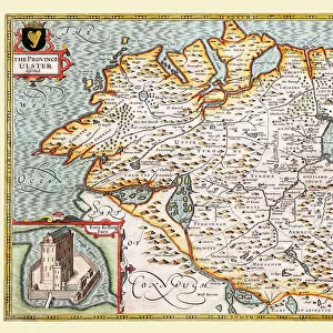
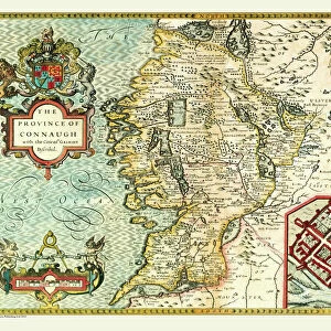
Old Map of The Province of Munster, Ireland 1611 by John Speed

![]()
Wall Art and Photo Gifts from MapSeeker
Old Map of The Province of Munster, Ireland 1611 by John Speed
A facimile of John Speeds historical map of the Province of Munster originally published for the " Theatre of the Empire of Great Britain", an atlas to accompany " a history of Great Britain"
Welcome to the Mapseeker Image library and enter an historic gateway to one of the largest on-line collections of Historic Maps, Nostalgic Views, Vista's and Panorama's from a World gone by.
Media ID 20347739
© Mapseeker Publishing Ltd
Historic Map John Speed Map Speed Map Speede Map Munster
FEATURES IN THESE COLLECTIONS
> Arts
> Artists
> S
> John Speed
> Europe
> Republic of Ireland
> Maps
> Maps and Charts
> British Empire Maps
> Maps and Charts
> Early Maps
> Maps and Charts
> Related Images
> MapSeeker
> Maps from the British Isles
> Ireland and Provinces PORTFOLIO
EDITORS COMMENTS
This print showcases an exquisite reproduction of the "Old Map of The Province of Munster, Ireland 1611" by John Speed. Originally published as part of the renowned "Theatre of the Empire of Great Britain" this map served as an essential component in illustrating the rich history and heritage of Great Britain. With intricate details and meticulous craftsmanship, John Speed's historical map offers a fascinating glimpse into the province of Munster during the early 17th century. From its vibrant cities to its sprawling landscapes, every corner is meticulously depicted, providing a visual journey through time. As one explores this facsimile edition, they will discover a wealth of information about Ireland's provinces and their interconnections. This particular map focuses on Munster—a region steeped in ancient folklore and storied traditions. Its rivers, mountains, towns, and castles are all carefully labeled with elegant calligraphy that adds to its allure. Whether you are an avid historian or simply captivated by cartography's beauty, this old map is sure to transport you back in time. It serves as a testament to John Speed's remarkable skill in capturing not only geographical accuracy but also cultural significance. Displaying this historic piece within your home or office will undoubtedly spark conversations about Ireland's past while adding a touch of timeless elegance to any space.
MADE IN AUSTRALIA
Safe Shipping with 30 Day Money Back Guarantee
FREE PERSONALISATION*
We are proud to offer a range of customisation features including Personalised Captions, Color Filters and Picture Zoom Tools
SECURE PAYMENTS
We happily accept a wide range of payment options so you can pay for the things you need in the way that is most convenient for you
* Options may vary by product and licensing agreement. Zoomed Pictures can be adjusted in the Cart.