Home > Arts > Artists > S > John Speed
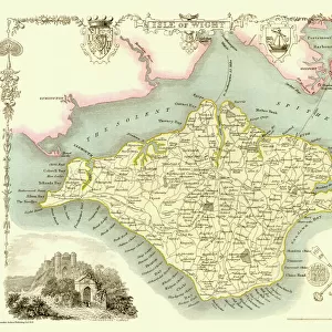
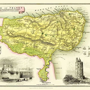
Old Map of The Isle of Wight 1611 by John Speed

![]()
Wall Art and Photo Gifts from MapSeeker
Old Map of The Isle of Wight 1611 by John Speed
A facimile of John Speeds historical map of the Isle of Wight originally published for the " Theatre of the Empire of Great Britain", an atlas to accompany " a history of Great Britain"
Welcome to the Mapseeker Image library and enter an historic gateway to one of the largest on-line collections of Historic Maps, Nostalgic Views, Vista's and Panorama's from a World gone by.
Media ID 20347572
© Mapseeker Publishing Ltd
Historic Map John Speed Map Speed Map Speede Map Isle Of Wight The Isle Of Wight
FEATURES IN THESE COLLECTIONS
> Arts
> Artists
> S
> John Speed
> Maps and Charts
> British Empire Maps
> Maps and Charts
> Early Maps
> Maps and Charts
> Related Images
> MapSeeker
> Maps from the British Isles
> Islands around Britain PORTFOLIO
EDITORS COMMENTS
This print showcases the remarkable "Old Map of The Isle of Wight 1611" by John Speed, a renowned cartographer and historian. Originally published for the esteemed "Theatre of the Empire of Great Britain" an atlas accompanying a comprehensive history of Great Britain, this facsimile allows us to delve into the rich historical tapestry woven across this enchanting island. With meticulous detail and artistry, Speed's map offers a fascinating glimpse into the past. Every contour, river, and settlement is intricately depicted, transporting us back in time to early 17th-century England. As we explore its faded parchment surface, we can almost hear echoes from centuries ago whispering tales of exploration and discovery. This historic map not only serves as a testament to Speed's mastery but also provides invaluable insights into the Isle of Wight's evolution over time. It invites us to trace ancient footpaths through dense forests, discover long-forgotten villages nestled along picturesque coastlines, and marvel at imposing castles that once stood tall against turbulent times. Whether you are an avid historian or simply captivated by maps' allure, this print is sure to ignite your imagination and kindle a sense of wonder about our collective past. Display it proudly on your wall or gift it to someone who shares your passion for unraveling history's mysteries – either way; it will undoubtedly become a cherished piece that sparks conversations and transports you on an unforgettable journey through time.
MADE IN AUSTRALIA
Safe Shipping with 30 Day Money Back Guarantee
FREE PERSONALISATION*
We are proud to offer a range of customisation features including Personalised Captions, Color Filters and Picture Zoom Tools
SECURE PAYMENTS
We happily accept a wide range of payment options so you can pay for the things you need in the way that is most convenient for you
* Options may vary by product and licensing agreement. Zoomed Pictures can be adjusted in the Cart.