Home > Europe > United Kingdom > Scotland > Dumfries and Galloway > Kirkcudbright
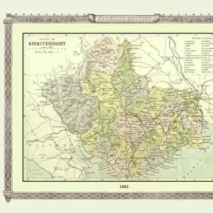
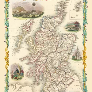
Old County Map of Kurkcudbright Scotland 1847 by A&C Black

![]()
Wall Art and Photo Gifts from MapSeeker
Old County Map of Kurkcudbright Scotland 1847 by A&C Black
A finely detailed facimile remastered in full colour from an antique original map of Kurkcudbright featured in A&C Blacks Atlas of 1847. Each Parish is numbered using an index table, colour rendition beautifully differentiating all of the Parishes. As well as principal roads, towns, villages and hamlets, these county maps of Scotland feature key battle sites marked with two crossed swords and the date of the battle
Welcome to the Mapseeker Image library and enter an historic gateway to one of the largest on-line collections of Historic Maps, Nostalgic Views, Vista's and Panorama's from a World gone by.
Media ID 20347443
© Mapseeker Publishing Ltd
A And C Black A And C Black Atlas A And C Black Map County Map County Map Of Scotland Historic Map Old County Map Old Scottish County Map Scottish County Map Kirkcudbright Kirkcudbrightshire
FEATURES IN THESE COLLECTIONS
> Arts
> Photorealistic artworks
> Detailed art pieces
> Masterful detailing in art
> Europe
> United Kingdom
> Scotland
> Dumfries and Galloway
> Kirkcudbright
> Europe
> United Kingdom
> Scotland
> Kirkcudbrightshire
> Europe
> United Kingdom
> Scotland
> Maps
> Maps and Charts
> Early Maps
> Maps and Charts
> Related Images
> MapSeeker
> Maps from the British Isles
> Scotland and Counties PORTFOLIO
EDITORS COMMENTS
This stunning print features an old county map of Kirkcudbright, Scotland from 1847 by A&C Black. Remastered in full color, this finely detailed facsimile brings to life the beauty and intricacy of the original antique map. Each parish is numbered using an index table, allowing for easy navigation and exploration of the area. What sets this historic map apart is its exquisite attention to detail. The color rendition beautifully differentiates all of the parishes, making it visually appealing and informative. In addition to highlighting principal roads, towns, villages, and hamlets, this county map also marks key battle sites with two crossed swords and their respective dates. Transporting you back in time, this print offers a glimpse into the rich history of Kirkcudbrightshire. Whether you are a history enthusiast or simply appreciate the charm of vintage maps, this piece will surely captivate your imagination. Perfect for home decor or as a gift for someone who cherishes Scottish heritage or historical artifacts, this old county map serves as both a decorative item and an educational resource. With its meticulous craftsmanship and fascinating details, it allows you to explore Kirkcudbrightshire's past while adding a touch of elegance to any space.
MADE IN AUSTRALIA
Safe Shipping with 30 Day Money Back Guarantee
FREE PERSONALISATION*
We are proud to offer a range of customisation features including Personalised Captions, Color Filters and Picture Zoom Tools
SECURE PAYMENTS
We happily accept a wide range of payment options so you can pay for the things you need in the way that is most convenient for you
* Options may vary by product and licensing agreement. Zoomed Pictures can be adjusted in the Cart.