Home > Europe > United Kingdom > Scotland > Maps
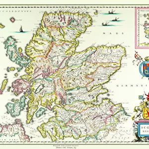
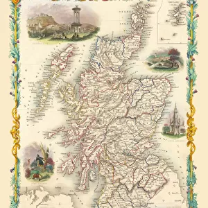
Old Map of Scotland 1611 by John Speed

![]()
Wall Art and Photo Gifts from MapSeeker
Old Map of Scotland 1611 by John Speed
A facimile of John Speeds historical map of Scotland originally published for the " Theatre of the Empire of Great Britain", an atlas to accompany " a history of Great Britain"
Welcome to the Mapseeker Image library and enter an historic gateway to one of the largest on-line collections of Historic Maps, Nostalgic Views, Vista's and Panorama's from a World gone by.
Media ID 20347745
© Mapseeker Publishing Ltd
Historic Map John Speed Map Old Map Of Scotland Old Scotland Map Old Scottish Map Scotland Scotland Map Scottish Map Speed Map John Speed
FEATURES IN THESE COLLECTIONS
> Arts
> Artists
> S
> John Speed
> Europe
> Republic of Ireland
> Maps
> Europe
> United Kingdom
> Scotland
> Maps
> Maps and Charts
> British Empire Maps
> Maps and Charts
> Early Maps
> Maps and Charts
> Related Images
> MapSeeker
> Maps from the British Isles
> Scotland and Counties PORTFOLIO
EDITORS COMMENTS
This print showcases an exquisite piece of history - the "Old Map of Scotland 1611" by John Speed. Originally published for the renowned "Theatre of the Empire of Great Britain" this facsimile allows us to delve into the rich cartographic heritage of Scotland. With intricate details and meticulous craftsmanship, Speed's map offers a glimpse into the past, transporting us back to a time when exploration and discovery were at their peak. As we explore this historical treasure, we can trace our fingers along ancient borders, marvel at long-forgotten place names, and immerse ourselves in Scotland's fascinating geography. From towering mountains to winding rivers, from bustling cities to remote villages, every inch of this map tells a story. It serves as a testament to both Speed's skill as a cartographer and his deep understanding of Scottish landscapes. As we gaze upon this old Scottish map with awe and curiosity, it reminds us that history is not just confined within textbooks; it lives on through artifacts like these. Whether you are an avid historian or simply fascinated by maps, this print invites you on an enchanting journey through time – where you can uncover hidden secrets and gain new insights into Scotland's past.
MADE IN AUSTRALIA
Safe Shipping with 30 Day Money Back Guarantee
FREE PERSONALISATION*
We are proud to offer a range of customisation features including Personalised Captions, Color Filters and Picture Zoom Tools
SECURE PAYMENTS
We happily accept a wide range of payment options so you can pay for the things you need in the way that is most convenient for you
* Options may vary by product and licensing agreement. Zoomed Pictures can be adjusted in the Cart.