Home > Europe > United Kingdom > Wales > Cardiganshire
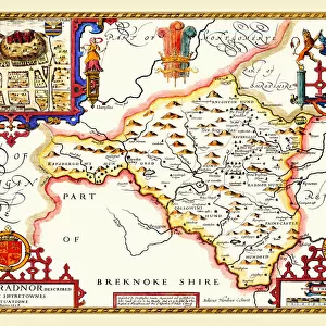
Old County Map of Cardiganshire 1611 by John Speed

![]()
Wall Art and Photo Gifts from MapSeeker
Old County Map of Cardiganshire 1611 by John Speed
A facimile of John Speeds historical map of Cardiganshire originally published for the " Theatre of the Empire of Great Britain", an atlas to accompany " a history of Great Britain"
Welcome to the Mapseeker Image library and enter an historic gateway to one of the largest on-line collections of Historic Maps, Nostalgic Views, Vista's and Panorama's from a World gone by.
Media ID 20347949
© Mapseeker Publishing Ltd
County Map County Map Of Wales Historic Map John Speed Map Old County Map Old Welsh County Map Speed Map Speede Map Welsh County Map Cardiganshire
FEATURES IN THESE COLLECTIONS
> Arts
> Artists
> S
> John Speed
> Europe
> United Kingdom
> Wales
> Cardiganshire
> Europe
> United Kingdom
> Wales
> Maps
> Europe
> United Kingdom
> Wales
> Posters
> Europe
> United Kingdom
> Wales
> Related Images
> Maps and Charts
> British Empire Maps
> Maps and Charts
> Early Maps
> Maps and Charts
> Related Images
> Maps and Charts
> Wales
> MapSeeker
> Maps from the British Isles
> Wales and Counties PORTFOLIO
EDITORS COMMENTS
This print showcases the intricate details of an "Old County Map of Cardiganshire 1611" by the renowned cartographer, John Speed. Originally published for the esteemed "Theatre of the Empire of Great Britain" this facsimile offers a glimpse into the historical significance and rich heritage of Cardiganshire. With its delicate lines and exquisite craftsmanship, this old Welsh county map transports us back in time to a bygone era. As we explore its contours, we are reminded of Speed's dedication to accuracy and his meticulous approach to cartography. Every village, river, and hill is meticulously depicted on this remarkable piece. As part of an atlas designed to accompany "A History of Great Britain" this map serves as both a geographical reference point and a window into the past. It allows us to trace the evolution of Cardiganshire over centuries and understand its place within Wales' broader context. Whether you have ancestral ties to Cardiganshire or simply appreciate historical maps, this stunning print offers a unique opportunity for exploration and discovery. Hang it proudly on your wall or use it as an educational tool – either way, it will undoubtedly spark conversations about our shared history. Let John Speed's masterful work transport you through time as you immerse yourself in the beauty and intricacy of this historic Cardiganshire map.
MADE IN AUSTRALIA
Safe Shipping with 30 Day Money Back Guarantee
FREE PERSONALISATION*
We are proud to offer a range of customisation features including Personalised Captions, Color Filters and Picture Zoom Tools
SECURE PAYMENTS
We happily accept a wide range of payment options so you can pay for the things you need in the way that is most convenient for you
* Options may vary by product and licensing agreement. Zoomed Pictures can be adjusted in the Cart.