Home > Europe > United Kingdom > Wales > Maps
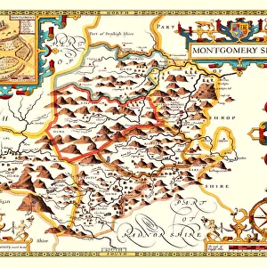
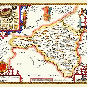
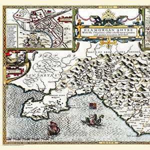
Old County Map of Monmouthshire 1611 by John Speed

![]()
Wall Art and Photo Gifts from MapSeeker
Old County Map of Monmouthshire 1611 by John Speed
A facimile of John Speeds historical map of Monmouthshire originally published for the " Theatre of the Empire of Great Britain", an atlas to accompany " a history of Great Britain"
Welcome to the Mapseeker Image library and enter an historic gateway to one of the largest on-line collections of Historic Maps, Nostalgic Views, Vista's and Panorama's from a World gone by.
Media ID 20347765
© Mapseeker Publishing Ltd
County Map County Map Of Wales Historic Map John Speed Map Old County Map Old Welsh County Map Speed Map Speede Map Welsh County Map Monmouthshire
FEATURES IN THESE COLLECTIONS
> Arts
> Artists
> S
> John Speed
> Europe
> United Kingdom
> Wales
> Maps
> Europe
> United Kingdom
> Wales
> Monmouthshire
> Related Images
> Europe
> United Kingdom
> Wales
> Posters
> Europe
> United Kingdom
> Wales
> Related Images
> Maps and Charts
> British Empire Maps
> Maps and Charts
> Early Maps
> Maps and Charts
> Related Images
> Maps and Charts
> Wales
> MapSeeker
> Maps from the British Isles
> Wales and Counties PORTFOLIO
EDITORS COMMENTS
This stunning print showcases the intricate details of the "Old County Map of Monmouthshire 1611" by John Speed. As a faithful reproduction of Speed's historical map, originally published for the renowned "Theatre of the Empire of Great Britain" this facsimile offers a captivating glimpse into the past. With its rich history and cultural significance, Monmouthshire comes to life in this old Welsh county map. Every line and contour tells a story, revealing the evolution and development of this remarkable region. From quaint villages to majestic castles, each landmark is meticulously depicted, providing an immersive experience for any history enthusiast or admirer of cartography. John Speed's expertise as both a historian and cartographer shines through in every stroke on this speede map. It serves as an invaluable resource for those seeking to explore the roots and heritage of Monmouthshire or delve deeper into British history as a whole. Whether displayed in your home or office, this historic map adds character and intrigue to any space. Its timeless charm invites you to embark on a visual journey through time while appreciating the artistry behind it. Step back in time with this extraordinary piece that captures not only Monmouthshire's essence but also celebrates John Speed's contribution to mapping our world. Discover why maps are more than just geographical representations; they are gateways into our collective pasts.
MADE IN AUSTRALIA
Safe Shipping with 30 Day Money Back Guarantee
FREE PERSONALISATION*
We are proud to offer a range of customisation features including Personalised Captions, Color Filters and Picture Zoom Tools
SECURE PAYMENTS
We happily accept a wide range of payment options so you can pay for the things you need in the way that is most convenient for you
* Options may vary by product and licensing agreement. Zoomed Pictures can be adjusted in the Cart.