Home > Europe > United Kingdom > Wales > Radnorshire
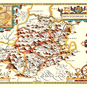
Old County Map of Radnorshire, Wales 1611 by John Speed

![]()
Wall Art and Photo Gifts from MapSeeker
Old County Map of Radnorshire, Wales 1611 by John Speed
A facimile of John Speeds historical map of Radnorshire originally published for the " Theatre of the Empire of Great Britain", an atlas to accompany " a history of Great Britain"
Welcome to the Mapseeker Image library and enter an historic gateway to one of the largest on-line collections of Historic Maps, Nostalgic Views, Vista's and Panorama's from a World gone by.
Media ID 20347707
© Mapseeker Publishing Ltd
County Map County Map Of Wales Historic Map John Speed Map Old County Map Old Welsh County Map Speed Map Speede Map Welsh County Map Radnorshire
FEATURES IN THESE COLLECTIONS
> Arts
> Artists
> S
> John Speed
> Europe
> United Kingdom
> Wales
> Maps
> Europe
> United Kingdom
> Wales
> Posters
> Europe
> United Kingdom
> Wales
> Radnorshire
> Europe
> United Kingdom
> Wales
> Related Images
> Maps and Charts
> British Empire Maps
> Maps and Charts
> Early Maps
> Maps and Charts
> Related Images
> Maps and Charts
> Wales
> MapSeeker
> Maps from the British Isles
> Wales and Counties PORTFOLIO
EDITORS COMMENTS
This print showcases the "Old County Map of Radnorshire, Wales 1611" by the renowned cartographer John Speed. A faithful reproduction of Speed's historical map, originally published for his monumental work "Theatre of the Empire of Great Britain" this piece offers a fascinating glimpse into the past. With intricate details and exquisite craftsmanship, this old Welsh county map takes us back to a time when Radnorshire was an integral part of Great Britain's rich history. The map is not just a geographical representation but also serves as an accompaniment to "A History of Great Britain" providing valuable insights into the region's cultural and political significance. As we explore this historic Radnorshire map, we are transported to a bygone era where boundaries were defined differently, and landscapes held undiscovered secrets. It invites us to immerse ourselves in its intricacies - from quaint villages nestled amidst rolling hills to ancient castles standing proudly against the horizon. John Speed's expertise shines through every stroke on this speede map; it is evident that he poured his heart and soul into creating an accurate depiction of Radnorshire. This remarkable piece allows us to appreciate both the artistry involved in cartography and our connection with our ancestors who once called these lands home. Whether you are a history enthusiast or simply captivated by maps' allure, this authentic replica offers endless opportunities for exploration and discovery. Let your imagination wander as you delve into the depths of Radnorshire's past through this extraordinary
MADE IN AUSTRALIA
Safe Shipping with 30 Day Money Back Guarantee
FREE PERSONALISATION*
We are proud to offer a range of customisation features including Personalised Captions, Color Filters and Picture Zoom Tools
SECURE PAYMENTS
We happily accept a wide range of payment options so you can pay for the things you need in the way that is most convenient for you
* Options may vary by product and licensing agreement. Zoomed Pictures can be adjusted in the Cart.