Home > Arts > Artists > O > John Ogilby
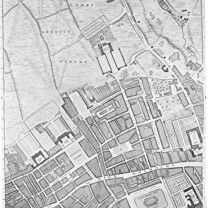
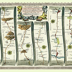
Old Road Strip Map (PLATE 11) The Continuation of the Road from London to the City of Bristol
 The Continuation of the Road from London to the City of Bristol")
![]()
Wall Art and Photo Gifts from MapSeeker
Old Road Strip Map (PLATE 11) The Continuation of the Road from London to the City of Bristol
OLG011
Welcome to the Mapseeker Image library and enter an historic gateway to one of the largest on-line collections of Historic Maps, Nostalgic Views, Vista's and Panorama's from a World gone by.
Media ID 20347295
John Ogilby Ogilby Old Road Strip Map Strip Map
FEATURES IN THESE COLLECTIONS
> Arts
> Artists
> O
> John Ogilby
> Maps and Charts
> Related Images
> MapSeeker
> Old Railway and Canal Map Collection
> Early Coaching Routes and Canal Maps
EDITORS COMMENTS
This print showcases an exquisite piece of history, the "Old Road Strip Map (PLATE 11) The Continuation of the Road from London to the City of Bristol". Created by the renowned cartographer John Ogilby, this strip map offers a fascinating glimpse into the past. The intricate details and meticulous craftsmanship of this map are truly awe-inspiring. It takes us on a journey along the ancient road that connects two iconic cities - London and Bristol. As we gaze upon it, we can almost imagine ourselves traversing through time, following in the footsteps of countless travelers who once relied on these very roads. Every inch of this strip map is filled with valuable information about landmarks, towns, and villages that dotted this historic route. It serves as a testament to Ogilby's expertise in accurately documenting geographical features during his time. This print not only captures the essence of Ogilby's work but also allows us to appreciate its artistic beauty. The delicate lines and vibrant colors bring life to each element depicted on this historical document. Whether you are an avid historian or simply intrigued by maps, this remarkable print will undoubtedly transport you back in time. It serves as a tangible connection between our modern world and centuries-old traditions of exploration and navigation.
MADE IN AUSTRALIA
Safe Shipping with 30 Day Money Back Guarantee
FREE PERSONALISATION*
We are proud to offer a range of customisation features including Personalised Captions, Color Filters and Picture Zoom Tools
SECURE PAYMENTS
We happily accept a wide range of payment options so you can pay for the things you need in the way that is most convenient for you
* Options may vary by product and licensing agreement. Zoomed Pictures can be adjusted in the Cart.