Home > Europe > Luxembourg > Heritage Sites > City of Luxembourg: its Old Quarters
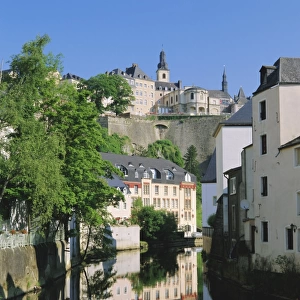
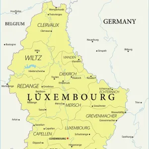
Aerial map view of Luxembourg City, Luxembourg

![]()
Wall Art and Photo Gifts from Mary Evans Picture Library
Aerial map view of Luxembourg City, Luxembourg
Aerial map view of Luxembourg City, Luxembourg, with roads and place names.
circa 1910
Mary Evans Picture Library makes available wonderful images created for people to enjoy over the centuries
Media ID 14248950
© Mary Evans/Pharcide
Luxembourg Names Postcards Roads
FEATURES IN THESE COLLECTIONS
> Aerial Photography
> Luxembourg
> Europe
> Luxembourg
> Heritage Sites
> City of Luxembourg: its Old Quarters
> Europe
> Luxembourg
> Luxembourg City
> Europe
> Luxembourg
> Maps
> Maps and Charts
> Luxembourg
EDITORS COMMENTS
1. Title: Aerial Map View of Luxembourg City, Luxembourg (circa 1910) 2. Description: This postcard presents an aerial map view of Luxembourg City, the historic capital of the European microstate of Luxembourg. The image, believed to have been captured around 1910, offers a unique perspective of the city's layout, with its intricate network of roads and place names clearly visible. 3. Background: Luxembourg City, nestled between France, Belgium, and Germany, is a testament to the rich history and cultural diversity of Europe. The city's layout, influenced by its strategic location and the natural fortifications of its surrounding hills, is evident in this early 20th-century map. 4. Key Features: The map reveals the city's major roads, such as the Grand Rue, Boulevard Royal, and Rue de Strasbourg, which are still significant thoroughfares today. Notable landmarks, including the Bock Casemates, the Grand Ducal Palace, and the Notre-Dame Cathedral, can also be identified. The city's unique green spaces, such as the Parc du Bock and the Alzette Valley, add to the picturesque scene. 5. Historical Context: This aerial map view offers a glimpse into the city's past, showcasing the urban development that had taken place by the early 1900s. The image serves as a reminder of the city's resilience and adaptability, as it continues to thrive as a modern European capital. 6. Conclusion: This postcard is an invaluable historical document, offering a fascinating insight into the layout and development of Luxembourg City during the 1910s. The aerial map view not only showcases the city's architectural and geographical features but also provides a captivating reminder of the city's rich history and European heritage.
MADE IN AUSTRALIA
Safe Shipping with 30 Day Money Back Guarantee
FREE PERSONALISATION*
We are proud to offer a range of customisation features including Personalised Captions, Color Filters and Picture Zoom Tools
SECURE PAYMENTS
We happily accept a wide range of payment options so you can pay for the things you need in the way that is most convenient for you
* Options may vary by product and licensing agreement. Zoomed Pictures can be adjusted in the Cart.