Home > Historic > Renaissance art > Northern Renaissance art
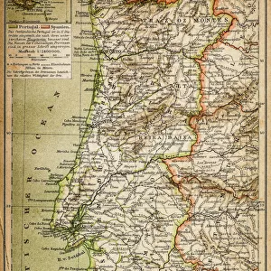
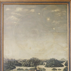
Atlas by Fern㯠Vaz Dourado, 1571. Chart 1: Northern

![]()
Wall Art and Photo Gifts from Mary Evans Picture Library
Atlas by Fern㯠Vaz Dourado, 1571. Chart 1: Northern
Atlas by Fern㯠 Vaz Dourado, 1571. Chart 1: Northern Europe. Renaissance art. Miniature Painting. PORTUGAL. Lisbon. National Archive of the Tower of the Tombo
Mary Evans Picture Library makes available wonderful images created for people to enjoy over the centuries
Media ID 14184933
© BeBa/Iberfoto/Mary Evans
1571 Archive Atlas Chart Fern Fernao Heraldry Iceland Icelandic Illuminated Lisbon Manuscript Manuscripts Miniatures Portugal Renaissance Russians Scandinavian Scandinavians Swede Sweden Swedes Swedish Times Europeans Icelander Tombo
FEATURES IN THESE COLLECTIONS
> Arts
> Art Movements
> Renaissance Art
> Europe
> Iceland
> Paintings
> Europe
> Portugal
> Paintings
> Europe
> United Kingdom
> Related Images
> Historic
> Renaissance art
> Northern Renaissance art
EDITORS COMMENTS
This stunningly intricate and colorful print is a chart, or map, extracted from the atlas "Atlas de Portugal e das Terras do Sul e Ocidente" (Atlas of Portugal and the Lands of the South and West), created by Fernão Vaz Dourado in 1571. The chart, specifically Chart 1, focuses on Northern Europe during the Renaissance era. This miniature painting, a testament to the artistic and cartographic prowess of the time, is part of the National Archive of the Tower of the Tombo in Lisbon, Portugal. The chart is filled with vibrant hues, meticulously drawn borders, and rich heraldic symbols representing various European countries. The map includes the United Kingdom and Ireland, with the British Isles depicted in detail. To the north, the Scandinavian countries of Sweden, Norway, and Denmark are shown, along with Iceland and its icelanders. The Eastern European countries of Russia and its people are also represented, reflecting the expanding knowledge and reach of the Portuguese during the early modern era. The chart's horizontal format and the use of color make it a valuable resource for understanding the geography and political landscape of Northern Europe during the 16th century. This illuminated manuscript is a testament to the artistic and cartographic achievements of the time and provides a fascinating glimpse into the history and culture of Europe during the Renaissance.
MADE IN AUSTRALIA
Safe Shipping with 30 Day Money Back Guarantee
FREE PERSONALISATION*
We are proud to offer a range of customisation features including Personalised Captions, Color Filters and Picture Zoom Tools
SECURE PAYMENTS
We happily accept a wide range of payment options so you can pay for the things you need in the way that is most convenient for you
* Options may vary by product and licensing agreement. Zoomed Pictures can be adjusted in the Cart.