Home > Europe > Netherlands > Maps
Atlas Novus, 17th c Le Theatre du Monde

![]()
Wall Art and Photo Gifts from Mary Evans Picture Library
Atlas Novus, 17th c Le Theatre du Monde
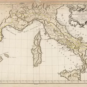
BLAEU, Jan (1596-1673). Atlas Novus or Atlas Maior. 1635 - 1665. Volume I. Europe, Germany and Netherlands. Detail of a map of Nuremberg (Territorium Norimbergese). Printed in Amsterdam, 1645. Etching. SPAIN. CATALONIA. Barcelona. Biblioteca de Catalunya (National Library of Catalonia)
Mary Evans Picture Library makes available wonderful images created for people to enjoy over the centuries
Media ID 14179454
© Iberfoto/Mary Evans
1571 1596 1635 1638 1645 1665 1673 Amsterdam Atlas Barcelona Biblioteca Blaeu Catalonia Catalunya Cities Engravings Etching Etchings Janszoon Maior Monde Netherlands Novus Nuremberg Rivers Willem Pegnitz Volume
FEATURES IN THESE COLLECTIONS
> Europe
> Germany
> Nuremberg
> Europe
> Netherlands
> Amsterdam
> Europe
> Netherlands
> Maps
> Europe
> Netherlands
> Rivers
> Maps and Charts
> Willem Janszoon Blaeu
EDITORS COMMENTS
This detail is taken from Atlas Novus, also known as Atlas Maior, a monumental atlas created by the renowned Dutch cartographer Jan Blaeu between 1635 and 1665. The image showcases a portion of the map of Europe, specifically focusing on the territories of Germany and the Netherlands, with an enlarged view of the city of Nuremberg, labeled as "Territorium Norimbergese." This section was printed in Amsterdam in 1645 using the etching technique. The map is part of the larger Le Theatre du Monde series, which was a significant contribution to the cartographic world during the 17th century. The atlas was a collaborative effort between Blaeu and his son, Willem Janszoon Blaeu, who continued the project after Jan's death in 1673. The map includes various rivers, such as the Danube, Rhine, and the Willhelm and Pegnitz rivers, which flow through Nuremberg. The intricate detailing of the cities and their fortifications is a testament to the meticulous craftsmanship of the mapmakers. Of particular interest is the region of Spain and Catalonia, which is depicted in the bottom right corner of the image. Barcelona, the second-largest city in Catalonia, is clearly labeled. Atlas Novus was a groundbreaking work for its time, providing an accurate and detailed representation of the world, making it an essential resource for explorers, scholars, and politicians alike. The richly colored and intricately detailed maps in this atlas continue to captivate and inspire cartographic enthusiasts and historians today.
MADE IN AUSTRALIA
Safe Shipping with 30 Day Money Back Guarantee
FREE PERSONALISATION*
We are proud to offer a range of customisation features including Personalised Captions, Color Filters and Picture Zoom Tools
SECURE PAYMENTS
We happily accept a wide range of payment options so you can pay for the things you need in the way that is most convenient for you
* Options may vary by product and licensing agreement. Zoomed Pictures can be adjusted in the Cart.