Home > Europe > United Kingdom > Maps
Continental drift diagrams

![]()
Wall Art and Photo Gifts from Mary Evans Picture Library
Continental drift diagrams
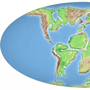
A) The continents 175 million years ago. B) The continents 50 million years ago. Figs 65 & 67 from The Age of the Earth. See also < a href= http://piclib.nhm.ac.uk/results.asp?image=006930 > 006930< /a>
Mary Evans Picture Library makes available wonderful images created for people to enjoy over the centuries
Media ID 8580111
© Mary Evans Picture Library 2015 - https://copyrighthub.org/s0/hub1/creation/maryevans/MaryEvansPictureID/10706366
Continental Continental Drift Diagram Drift Earth Geological Geology Movement Tectonics Landmass
FEATURES IN THESE COLLECTIONS
> Europe
> United Kingdom
> Maps
> Maps and Charts
> Geological Map
EDITORS COMMENTS MADE IN AUSTRALIA
FREE PERSONALISATION* SECURE PAYMENTS * Options may vary by product and licensing agreement. Zoomed Pictures can be adjusted in the Cart.
1. Title: Continental Drift: A Geological Journey Through Time Figures 65 and 67 from "The Age of the Earth" provide a fascinating glimpse into the past, illustrating the movement and shifting positions of continents over a span of approximately 125 million years. These diagrams, A and B, depict the positions of the continents around 175 million and 50 million years ago, respectively. A. Around 175 million years ago, the continents appeared fragmented and dispersed, with Pangaea, the supercontinent, beginning to break apart. The northern hemisphere was dominated by Laurasia, while the southern hemisphere was home to Gondwana. The Atlantic Ocean was just starting to form, while the Indian subcontinent was still attached to Antarctica. B. Fast forward to around 50 million years ago, and significant changes have taken place. The continents have continued to drift apart, leading to the formation of the North and South Atlantic Oceans. Europe and North America have moved further apart, while India has separated from Antarctica and begun its journey towards the Eurasian continent. The continental drift, a fundamental concept in the field of geology and tectonics, describes the large-scale movement of the Earth's landmasses over geological timescales. This process, driven by the movement of the underlying tectonic plates, has shaped the Earth's geography and continues to influence our planet today. These continental drift diagrams offer a captivating visual representation of the Earth's dynamic history, providing valuable insights into the geological processes that have shaped our planet over millions of years. [For more information on continental drift and related topics, please visit the following links: 1.
Safe Shipping with 30 Day Money Back Guarantee
We are proud to offer a range of customisation features including Personalised Captions, Color Filters and Picture Zoom Tools
We happily accept a wide range of payment options so you can pay for the things you need in the way that is most convenient for you
Related Images
Shipping
Choices
Reviews
Guaranteed
Related Collections