Home > Arts > Landscape paintings > Waterfall and river artworks > River artworks
Daily Mail coloured map of part of the Western Front

![]()
Wall Art and Photo Gifts from Mary Evans Picture Library
Daily Mail coloured map of part of the Western Front
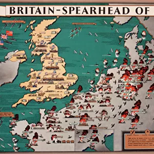
Daily Mail coloured print of a map of part of the Western Front from Bethune and La Bassee in the North to Albert and Peronne in the South with Arras in the centre of the map. It shows the towns, villages, woods and rivers. Scale = 1" to the mile. English School Date: Circa 1917
Mary Evans Picture Library makes available wonderful images created for people to enjoy over the centuries
Media ID 14149752
© David Cohen Fine Art/Mary Evans Picture Library
Arras Bassee Bethune Daily Mail Mile Peronne Rivers Scale Topographical Woods Albert
FEATURES IN THESE COLLECTIONS
> Arts
> Landscape paintings
> Waterfall and river artworks
> River artworks
> Maps and Charts
> Early Maps
> Maps and Charts
> World
EDITORS COMMENTS
This coloured map print, published by an English school around 1917, offers a detailed and vibrant representation of a part of the Western Front during World War I. The map stretches from Bethune and La Bassée in the north to Albert and Peronne in the south, with Arras serving as the central point. The intricate depiction includes various towns, villages, woods, and rivers that played significant roles in the military campaigns of the First Great War. The map's scale of 1 inch to the mile allows for a clear understanding of the geographical layout of the region, providing valuable context for students and historians studying the events of WWI. This topographical representation offers a unique glimpse into the strategic importance of the Western Front and the complexities of the military engagements that took place during this period. The map's rich colours and meticulous detail add an engaging visual element to the historical record, making it an essential addition to any collection focused on military history or the study of World War I. The map serves as a testament to the intricacy and complexity of the battles fought on the Western Front and the vital role that geographical knowledge played in shaping the course of the war.
MADE IN AUSTRALIA
Safe Shipping with 30 Day Money Back Guarantee
FREE PERSONALISATION*
We are proud to offer a range of customisation features including Personalised Captions, Color Filters and Picture Zoom Tools
SECURE PAYMENTS
We happily accept a wide range of payment options so you can pay for the things you need in the way that is most convenient for you
* Options may vary by product and licensing agreement. Zoomed Pictures can be adjusted in the Cart.