Home > Europe > United Kingdom > England > London > Transport > Railway
Development of French Africa by G. H. Davis

![]()
Wall Art and Photo Gifts from Mary Evans Picture Library
Development of French Africa by G. H. Davis
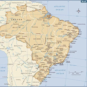
The vast economic development of French Africa: roads and communications from Algeria to Congo. A contour map of French African possessions under Allied control at this stage of the Second World War, showing roads, railways and air communications. Inset is a map showing transport routes between French West Africa and Brazil. Date: 1943
Mary Evans Picture Library makes available wonderful images created for people to enjoy over the centuries
Media ID 14125806
© Illustrated London News Ltd/Mary Evans
1943 Algeria Allied Atlantic Brazil Congo Contour Control Davis Development Economic Latin Maps Possessions Railways Roads Routes
FEATURES IN THESE COLLECTIONS
> Animals
> Birds
> Gruiformes
> Rallidae
> African Rail
> Europe
> United Kingdom
> England
> London
> Transport
> Railway
> Maps and Charts
> Early Maps
> Maps and Charts
> World
> South America
> Brazil
> Maps
EDITORS COMMENTS
This print, titled "The Vast Economic Development of French Africa: Roads and Communications from Algeria to Congo," showcases a contour map of French African possessions under Allied control during the Second World War. The map highlights the extensive network of roads, railways, and air communications that connected various regions of French Africa, demonstrating the significant strides made in infrastructure development during this period. The map covers an expansive area, stretching from Algeria in the north to the Congo in the south, and from Mauritania in the west to Chad in the east. The intricate web of transport routes is evident, with major arteries crisscrossing the continent and connecting it to key ports on the Atlantic Ocean. An inset map in the lower right corner of the print reveals the transport routes between French West Africa and Brazil, highlighting the importance of the Atlantic Ocean as a crucial transportation hub during this time. The map also underscores the strategic location of French Africa in the context of global wartime logistics, with the continent serving as a vital link between Europe, the Americas, and the Middle East. Created in 1943 by renowned cartographer G.H. Davis, this map offers a fascinating glimpse into the economic development of French Africa during the Second World War. The meticulous detail and accuracy of the map underscore the significant progress made in infrastructure development during this period, which would continue to shape the economic and geopolitical landscape of the continent for decades to come.
MADE IN AUSTRALIA
Safe Shipping with 30 Day Money Back Guarantee
FREE PERSONALISATION*
We are proud to offer a range of customisation features including Personalised Captions, Color Filters and Picture Zoom Tools
SECURE PAYMENTS
We happily accept a wide range of payment options so you can pay for the things you need in the way that is most convenient for you
* Options may vary by product and licensing agreement. Zoomed Pictures can be adjusted in the Cart.