Home > Europe > United Kingdom > Scotland > Aberdeenshire > Aberdeen
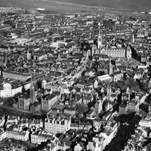
Harbour and part of the city of Aberdeen

![]()
Wall Art and Photo Gifts from Mary Evans Picture Library
Harbour and part of the city of Aberdeen
Detailed plan of Aberdeen Harbour and a section of the city of Aberdeen, including part of the River Dee. Date: 1838
Mary Evans Picture Library makes available wonderful images created for people to enjoy over the centuries
Media ID 14122952
© Mary Evans Picture Library/Ins. of Civil Engineers
Aberdeen Dock Docks Plan Quay Quays
FEATURES IN THESE COLLECTIONS
> Europe
> United Kingdom
> Scotland
> Aberdeen
> Europe
> United Kingdom
> Scotland
> Aberdeenshire
> Aberdeen
> Europe
> United Kingdom
> Scotland
> Maps
> Europe
> United Kingdom
> Scotland
> Rivers
> Maps and Charts
> Early Maps
EDITORS COMMENTS
This intricately detailed plan of Aberdeen Harbour and a section of the city, dating back to 1838, provides a captivating glimpse into the history of Aberdeen, Scotland. The map highlights the bustling harbour area, with its extensive docks and quays, which played a pivotal role in the city's economic growth during the Industrial Revolution. The River Dee, a prominent feature of the scene, winds its way through the heart of the city, connecting Aberdeen to the North Sea. The plan reveals the layout of the Aberdonian streets and buildings, showcasing the mix of architectural styles that define the city. The Old Town, with its narrow, winding lanes and medieval structures, stands in stark contrast to the more modern, grid-like layout of the New Town. The presence of the Marischal College, a grand 16th-century building and once the largest granite structure in the world, is a testament to Aberdeen's rich history. The harbour, a vital hub of activity, is depicted with an impressive array of ships, anchored or undergoing repairs. The intricate network of docks and quays, designed to accommodate various types of vessels, reflects the city's importance as a trading port. The presence of cranes and other loading equipment indicates the constant movement of goods, both imported and exported. This historical map offers a unique perspective on Aberdeen's past, providing valuable insights into the city's development and its role as a major Scottish port. The intricate details and meticulous accuracy make it an essential resource for historians, genealogists, and anyone with an interest in the history of Aberdeen and Scotland.
MADE IN AUSTRALIA
Safe Shipping with 30 Day Money Back Guarantee
FREE PERSONALISATION*
We are proud to offer a range of customisation features including Personalised Captions, Color Filters and Picture Zoom Tools
FREE COLORIZATION SERVICE
You can choose advanced AI Colorization for this picture at no extra charge!
SECURE PAYMENTS
We happily accept a wide range of payment options so you can pay for the things you need in the way that is most convenient for you
* Options may vary by product and licensing agreement. Zoomed Pictures can be adjusted in the Cart.