Home > People > Politicians
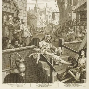
The Illustrated London News - Diamond Chart Election Map

![]()
Wall Art and Photo Gifts from Mary Evans Picture Library
The Illustrated London News - Diamond Chart Election Map
The Illustrated London News - Diamond Chart Election Map: The Position of the Parties - also featuring politica thermometers ! Date: 1910
Mary Evans Picture Library makes available wonderful images created for people to enjoy over the centuries
Media ID 19729420
© Illustrated London News Ltd/Mary Evans
Battlefield Candidate Chart Constituencies Constituency Diamond Diamonds Election Electoral News Parliament Parties Politicians Position Representation Swing Voting
FEATURES IN THESE COLLECTIONS
> Europe
> United Kingdom
> England
> London
> Politics
> Related Images
> Maps and Charts
> Related Images
> People
> Politicians
EDITORS COMMENTS
This print from The Illustrated London News, dated 1910, showcases the Diamond Chart Election Map, an intricate and visually striking representation of the political landscape during the general election of that year. The map, adorned with diamonds, serves as a visual guide to the electoral battlefield, with each constituency marked by a diamond that changes color based on the political allegiance of its candidate and the swing towards or away from each party. The layout of the map is designed to provide a clear and concise overview of the political representation in the country, with the size of each diamond proportional to the number of Members of Parliament (MPs) each party holds in the constituency. The use of thermometers, located at the bottom of the map, adds an additional layer of information, illustrating the temperature of the political climate in each region. The Diamond Chart Election Map offers a fascinating glimpse into the political dynamics of the time, providing valuable insights into the position of the parties and the electoral swing in various constituencies. With the general election of 1910 marking a pivotal moment in British political history, this map serves as an essential historical document, shedding light on the complexities of the electoral process and the intricacies of party politics during this period. The map's captivating design and wealth of information make it an invaluable resource for scholars, historians, and anyone interested in the history of British politics. This print from The Illustrated London News is not only a testament to the power of visual storytelling but also a reminder of the importance of understanding the political landscape and the role of representation in shaping the course of history.
MADE IN AUSTRALIA
Safe Shipping with 30 Day Money Back Guarantee
FREE PERSONALISATION*
We are proud to offer a range of customisation features including Personalised Captions, Color Filters and Picture Zoom Tools
SECURE PAYMENTS
We happily accept a wide range of payment options so you can pay for the things you need in the way that is most convenient for you
* Options may vary by product and licensing agreement. Zoomed Pictures can be adjusted in the Cart.