Home > Europe > United Kingdom > England > Buckinghamshire > High Wycombe
London to Aberistwith Map

![]()
Wall Art and Photo Gifts from Mary Evans Picture Library
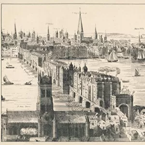
London to Aberistwith Map
London to Aberistwith as scroll maps. The first part London through Buckinghamshire to Oxford and Worcester surveyed by John Ogilby
Mary Evans Picture Library makes available wonderful images created for people to enjoy over the centuries
Media ID 14167052
© Walter Rawlings / Mary Evans Picture Library
Journey Oxford Route Scroll Worcester High Wycombe Islip
FEATURES IN THESE COLLECTIONS
> Arts
> Artists
> O
> John Ogilby
> Europe
> United Kingdom
> England
> Buckinghamshire
> High Wycombe
> Europe
> United Kingdom
> England
> London
> Related Images
> Maps and Charts
> Early Maps
EDITORS COMMENTS
1. Title: "A Journey Through Time: London to Aberystwyth - A Historical Scroll Map" This exquisite scroll map depicts the historic route from London to Aberystwyth, meticulously surveyed by the renowned English cartographer John Ogilby between 1675 and 1678. The map is a captivating testament to the rich history of travel and cartography in England during the late 17th century. The map begins in London, the bustling heart of the British Empire, and follows the ancient Roman road, Fosse Way, as it winds its way through Buckinghamshire. The route then passes through the picturesque market town of Islip, with its quaint thatched-roof cottages and ancient church. As the map progresses, it takes us through High Wycombe, the historic chair-making town, and onwards to Oxford, the city of dreaming spires and home to the oldest university in the English-speaking world. The map then continues its journey westward, crossing the River Severn and entering the historic county of Worcester. The final leg of the journey takes us through the beautiful Welsh countryside, culminating in the arrival at Aberystwyth, a picturesque seaside town nestled on the shores of Cardigan Bay. The map provides a fascinating insight into the topography, history, and culture of the areas through which it passes, making it an essential resource for anyone interested in the history of travel and cartography. John Ogilby's London to Aberystwyth scroll map is not only a beautiful work of art but also a valuable historical document, offering a unique perspective on the journey from London to Wales during the late 17th century. This map is a must-have for historians, cartographers, and anyone with an interest in the history of travel and exploration.
MADE IN AUSTRALIA
Safe Shipping with 30 Day Money Back Guarantee
FREE PERSONALISATION*
We are proud to offer a range of customisation features including Personalised Captions, Color Filters and Picture Zoom Tools
SECURE PAYMENTS
We happily accept a wide range of payment options so you can pay for the things you need in the way that is most convenient for you
* Options may vary by product and licensing agreement. Zoomed Pictures can be adjusted in the Cart.


![G. W. R & G. C. R Joint Line - New Station at High Wycombe Up Platform [1902]](/sq/229/g-w-r-g-c-r-joint-line-new-station-high-11067587.jpg.webp)