Fraud Blocker Skip to main content

Home > Arts > Artists > S > Syrian Syrian

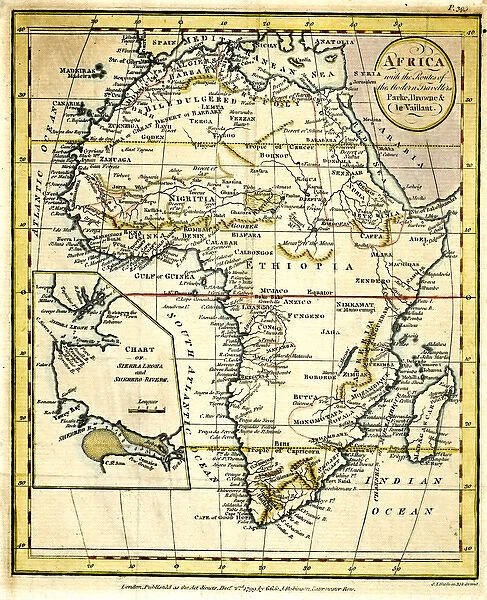
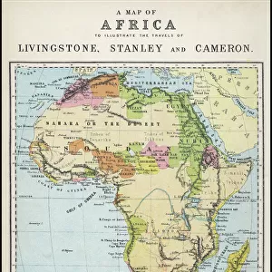
Map of Africa, with travellers routes

 : Map of Africa, with travellers routes
In Stock
We accept all major payment options so you can pay for the things you need in the way that is most convenient for you

Choose Your Product

Framed Photos
Buy from AU$119.99
Photo Prints
Buy from AU$12.99
Jigsaw Puzzles
Buy from AU$89.99
Poster Prints
Buy from AU$24.99
Canvas Prints
Buy from AU$124.99
Fine Art Prints
Buy from AU$92.53
Metal Prints
Buy from AU$43.99
Cards
Buy from AU$12.99
Home Decor
Buy from AU$24.99

Mary Evans Picture Library Photo Prints and Wall Art

Map of Africa, with travellers routes

Map of Africa, with the routes of the modern travellers, Parke, Browne and Le Vaillant.
1799. Mary Evans Picture Library makes available wonderful images created for people to enjoy over the centuries. © Mary Evans Picture Library

Media ID 14416346

1790s 1799 Arabia Browne Continent Ethiopia Guinea Leone Madagascar Maps Mediterranean Parke Routes Sierra Syria Travellers Vaillant

FEATURES IN THESE COLLECTIONS

> Africa > Ethiopia (Abyssinia) > Related Images

> Africa > Ethiopia > Related Images

> Africa > Guinea > Maps

> Africa > Guinea > Related Images

> Africa > Madagascar > Maps

> Africa > Madagascar > Related Images

> Africa > Sierra Leone > Maps

> Africa > Sierra Leone > Related Images

> Arts > Artists > S > Syrian Syrian

> Asia > Syria > Maps

SECURE PAYMENTS
We accept all major payment options so you can pay for the things you need in the way that is most convenient for you

Made in Australia
Safe Shipping, Easy Returns

FREE PERSONALISATION
We are proud to offer a range of customisation including Cropping, Captions, and Filters. Zoom Cropping can be adjusted in the basket


EDITORS COMMENTS

This hand-coloured map, dating back to 1799, offers a fascinating glimpse into the exploratory spirit of the 1790s as it depicts Africa with the recorded routes of notable travellers Parke, Browne, and Le Vaillant. The map, held in the esteemed collection of Mary Evans Picture Library, provides a detailed representation of the African continent during a time when European exploration was at its height. The map is adorned with intricate colouring, highlighting various geographical features such as the vast Sahara Desert, the Nile River, and the Red Sea. The Mediterranean Sea and the Indian Ocean encircle the continent, reflecting the significance of maritime exploration during this era. The map also shows the territories of Spain and Portugal, reflecting their colonial influence in Africa. At the bottom of the map, the routes of Parke, Browne, and Le Vaillant are marked, providing a testament to their intrepid journeys across the African continent. Parke's route is shown from Tripoli to Timbuktu, Browne's from the Mediterranean to the Cape of Good Hope, and Le Vaillant's from the Cape of Good Hope to Ethiopia. These explorers' accounts provided valuable information about the African continent, contributing to the growing body of knowledge about the diverse cultures, landscapes, and peoples of Africa. The map also features labels for various African countries, including Madagascar, Ethiopia, Sierra Leone, and Guinea, among others. The map's intricate details and historical significance make it an essential resource for scholars, historians, and anyone interested in the history of exploration and the African continent.


Framed Prints of Map of Africa, with travellers routes

Discover the rich history of African exploration with our stunning Framed Prints from Media Storehouse, featuring the captivating Map of Africa by Mary Evans Picture Library. This vintage map, dating back to 1799, beautifully illustrates the routes of early travellers, including Parke, Browne, and Le Vaillant. Each Framed Print is meticulously crafted with high-quality materials, ensuring a vivid and long-lasting display. Add this unique piece to your home or office décor and transport yourself on a journey through time, celebrating the spirit of adventure and discovery.


Photo Prints of Map of Africa, with travellers routes

Discover the rich history of African exploration with our stunning Map of Africa print from Mary Evans Picture Library. This beautiful vintage map, dating back to 1799, highlights the travel routes of notable explorers such as Parke, Browne, and Le Vaillant. Transport yourself back in time as you trace the journeys of these intrepid adventurers across the vast and intriguing African continent. Our high-quality photographic print is perfect for adding a touch of history and character to any room. Order now and bring a piece of the past into your home.


Poster Prints of Map of Africa, with travellers routes

Discover the rich history of African exploration with our stunning Map of Africa print from Mary Evans Picture Library. This captivating poster, dating back to 1799, features the routes taken by famous travellers Parke, Browne, and Le Vaillant. Add an air of adventure to your space with this intricately detailed and historically significant print from the Media Storehouse range of poster prints. Bring the past to life in your home or office, and transport yourself on a journey of discovery. Order now and let this beautiful piece of history be the conversation starter in your room.


Jigsaw Puzzles of Map of Africa, with travellers routes

Discover the rich history and wonders of Africa with our captivating jigsaw puzzles from Media Storehouse. This intricately detailed puzzle features a vintage map of Africa, beautifully illustrated by Mary Evans Picture Library from Mary Evans Prints Online. Dated back to 1799, this map showcases the travel routes of famous explorers, including Parke, Browne, and Le Vaillant. Assemble this puzzle to bring the stories of these intrepid adventurers to life in your home. Engage in a fun and educational activity that will transport you to a different time and place.

diamond
Made With High Grade Materials
thumb_up
Professional Quality Finish
package_2
Carefully Packed To Aid Safe Arrival

You May Also Like


Sierra Leone country mapSierra Leone country map
Add to Basket
Period costumes French Directory. 1795-1799. Engraving. 19thPeriod costumes French Directory. 1795-1799. Engraving. 19th
Add to Basket
At the Gates, Fort Belvedere, 1936 (1937)At the Gates, Fort Belvedere, 1936 (1937)
Add to Basket
A tramway in Alfama district with the Motherchurch (Se Catedral) in the backgroundA tramway in Alfama district with the Motherchurch (Se Catedral) in the background
Add to Basket
Street corner, Freetown, Sierra Leone, West AfricaStreet corner, Freetown, Sierra Leone, West Africa
Add to Basket
Battle of CorunnaBattle of Corunna
Add to Basket
Battle of Quatre BrasBattle of Quatre Bras
Add to Basket
Epipactis palustris, marsh helliborineEpipactis palustris, marsh helliborine
Add to Basket
Magical Underwater WorldMagical Underwater World
Add to Basket
Los Caprichos by Francisco de Goya (1746-1828)Los Caprichos by Francisco de Goya (1746-1828)
Add to Basket
Gregory GrantGregory Grant
Add to Basket
Sir Peter FairbairnSir Peter Fairbairn
Add to Basket

Gallery Wall Inspiration

Saladin and Guy de Lusignan after battle of Hattin in 1187. Painting by Said Tahsine (1904-1985), 1954
SAINTS SERGIUS AND BACCHUS. Byzantine icon of Saint Sergius and Saint Bacchus
Israel Country Map 2011 Edition
Abraham receives the promise (tempera on plaster)
Apostle Pauls Missionary Journeys, lithograph, published in 1886
Syria and Lebanon holiday poster
Map of ancient Palestine kingdoms of Judah and Israel
Sir Richard Francis Burton (1821-1890)
Krak des Chevaliers, famous Crusader Castle near Homs, Syria
Map of Palestine and the Holy Land
IAMBLICHUS
Map of Palestine, 1588
Poster advertising the Baron Hotel in Aleppo, c. 1920 (colour litho)
Grand Portico of the Temple of Philae - Nubia, 1842-1849 (tinted lithograph)
Map of the Battle of Alexandria, published by William Blackwood and Sons
Mideast map during the Crusades
Syrian Hamster in flowers
Burj Safita, Syria XAWF04840
LEBANON: BEIRUT, c1895. View of Beirut, Lebanon. Photochrome, c1895
Roman Theatre Of Palmyra, Syria
Lincoln classic car
Map of Napoleons Campaign in Egypt 1798 - French campaign in Egypt and Syria
Monumental Arch, Palmyra, Syria
Latakia, Syria - General view
Aleppo, Syria - The Citadel - Gatehouse and Entrance
View of the city de Damascus, Syrian anonymous
Emir Faisal at Wejh (now in Saudi Arabia)

Discover Our Collections


Ethiopia (Abyssinia) Related ImagesEthiopia (Abyssinia) Related Images
View Collection
Guinea Related ImagesGuinea Related Images
View Collection
Madagascar Related ImagesMadagascar Related Images
View Collection
Sierra Leone Related ImagesSierra Leone Related Images
View Collection
MapsMaps
View Collection
MapsMaps
View Collection
MapsMaps
View Collection
MapsMaps
View Collection
Syrian SyrianSyrian Syrian
View Collection
Ethiopia Related ImagesEthiopia Related Images
View Collection


© Copyright Media Storehouse, All Rights Reserved 2003 - 2025
Facebook     Pinterest     100% Payment Secure     Reviews IO