Home > Europe > United Kingdom > England > London > Boroughs > City of London
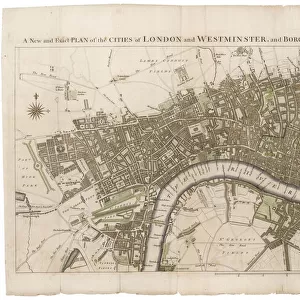
Map of the City of London by John Ogilby 1676. Ogilby (also Ogelby

![]()
Wall Art and Photo Gifts from Mary Evans Picture Library
Map of the City of London by John Ogilby 1676. Ogilby (also Ogelby
Map of the City of London by John Ogilby 1676. Ogilby (also Ogelby, Oglivie - 16001676) was a Scottish translator, impresario and cartographer. Best known for publishing the first British road atlas, he was also a successful translator, noted for publishing his work in handsome illustrated editions. Date: 1676
Mary Evans Picture Library makes available wonderful images created for people to enjoy over the centuries
Media ID 20029070
© Mary Evans Picture Library
1670s 1676 Atlas Capital Cartographer Cartography Draughtsman Impresario Plan Translator Mapmaker Ogilby
FEATURES IN THESE COLLECTIONS
> Arts
> Artists
> O
> John Ogilby
> Europe
> United Kingdom
> England
> London
> Boroughs
> City of London
> Europe
> United Kingdom
> England
> London
> River Thames
EDITORS COMMENTS
This stunning map print, titled "Map of the City of London and the Boroughs of Southwark and Bermondsey," is a testament to the cartographic prowess of John Ogilby (1600-1676), a Scottish polymath who made significant contributions to the fields of cartography, translating, and impresarial activities during the 17th century. Ogilby, also known by the variant spellings Ogelby and Oglivie, is best remembered for publishing the first British road atlas in 1675. However, this map of London, created in 1676, showcases his exceptional skill as a mapmaker and draughtsman. The intricate detailing of the map is evident in the depiction of the city's streets, buildings, and topography, as well as the winding Thames River and its surrounding docks. The map also highlights the Boroughs of Southwark and Bermondsey, which were important commercial and industrial areas during the 17th century. Ogilby's meticulous attention to detail is further demonstrated by the inclusion of various points of interest, such as churches, schools, and markets. This map is a captivating representation of London during the 1670s and offers a unique glimpse into the city's history. The richly detailed illustrations and elegant design make this a valuable addition to any collection of historical maps or London memorabilia.
MADE IN AUSTRALIA
Safe Shipping with 30 Day Money Back Guarantee
FREE PERSONALISATION*
We are proud to offer a range of customisation features including Personalised Captions, Color Filters and Picture Zoom Tools
SECURE PAYMENTS
We happily accept a wide range of payment options so you can pay for the things you need in the way that is most convenient for you
* Options may vary by product and licensing agreement. Zoomed Pictures can be adjusted in the Cart.