Home > Africa > Zambia > Maps
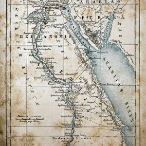
Map Egypt and Sudan

![]()
Wall Art and Photo Gifts from Mary Evans Picture Library
Map Egypt and Sudan
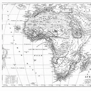
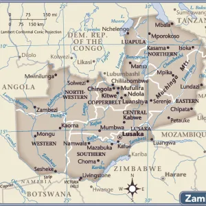
Map covering the area from the Nile delta to the Mountains of the Moon. Zambia and the Zaire river are marked. Date: 16th century
Mary Evans Picture Library makes available wonderful images created for people to enjoy over the centuries
Media ID 14113533
© Mary Evans Picture Library
Area Covering Delta Maps Marked Moon Nile Sudan Zaire Zambia
FEATURES IN THESE COLLECTIONS
> Maps and Charts
> Early Maps
EDITORS COMMENTS
1. Title: "Exploring the Nile: A 16th Century Map of Egypt and Sudan" This map print dates back to the 16th century and offers a fascinating glimpse into the geographical knowledge of the time. The map covers an extensive area from the Nile Delta in Egypt to the Mountains of the Moon in Sudan, providing valuable historical context for the exploration and understanding of this region during the European Age of Discovery. The map's primary focus is on the Nile River, which is depicted with remarkable detail, from its delta in the Mediterranean Sea to its source in central Africa. The two major tributaries, the White Nile and the Blue Nile, are clearly marked, providing essential information for early European explorers and traders. Beyond the Nile, the map also highlights other notable features of the region, including the Sahara Desert, the Red Sea, and the Sudanese provinces of Bahr el-Ghazal and Darfur. The map also marks the location of the Kingdom of Zimbabwe, which was a significant power center in southern Africa during this period. One intriguing feature of this map is the inclusion of the Zaire River, which was not discovered until the late 15th century. This suggests that the map was compiled from multiple sources and reflects the growing European interest in the geography and resources of Africa during the 16th century. Overall, this map print offers a unique window into the historical cartography of Africa and the early European exploration of the continent. Its intricate details and accurate depictions of geographical features make it an essential resource for scholars, historians, and anyone interested in the rich history of Egypt and Sudan.
MADE IN AUSTRALIA
Safe Shipping with 30 Day Money Back Guarantee
FREE PERSONALISATION*
We are proud to offer a range of customisation features including Personalised Captions, Color Filters and Picture Zoom Tools
FREE COLORIZATION SERVICE
You can choose advanced AI Colorization for this picture at no extra charge!
SECURE PAYMENTS
We happily accept a wide range of payment options so you can pay for the things you need in the way that is most convenient for you
* Options may vary by product and licensing agreement. Zoomed Pictures can be adjusted in the Cart.