Home > Historic > Ancient civilizations > Ancient Greece > Greek history
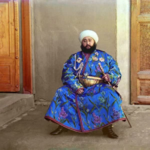
A Map of the Island of Chios

![]()
Wall Art and Photo Gifts from Mary Evans Picture Library
A Map of the Island of Chios
A Turkish Map of the Greek Island of Chios, at this point under Ottoman Turkish control. The island is in the Aegean Sea only 5 miles off the coast of Asia Minor
Mary Evans Picture Library makes available wonderful images created for people to enjoy over the centuries
Media ID 4462579
© Mary Evans Picture Library 2015 - https://copyrighthub.org/s0/hub1/creation/maryevans/MaryEvansPictureID/10415528
FEATURES IN THESE COLLECTIONS
> Asia
> Related Images
> Historic
> Ancient civilizations
> Ancient Greece
> Greek history
> Maps and Charts
> Early Maps
EDITORS COMMENTS
1. Title: "A Glimpse into the Past: An Ottoman Turkish Map of the Island of Chios, 16th Century" This antique map print showcases the Island of Chios, located in the Aegean Sea, during the 16th century when it was under Ottoman Turkish control. The map, intricately detailed and adorned with elegant script, offers a fascinating glimpse into the rich history of this Greek island, which lies just five miles off the coast of Asia Minor. The map's Turkish script, written in a bold and flowing hand, reveals the names of various towns, villages, and landmarks scattered across the island. The text also includes important geographical features such as bays, capes, and mountains. The cartographer's meticulous attention to detail is evident in the precise depiction of the island's coastline, with its winding bays, rocky cliffs, and sandy beaches. The Ottoman Empire, which ruled over Chios from the late 14th century until the early 20th century, left an indelible mark on the island's history and culture. This map serves as a testament to that era, providing a valuable record of the island's topography and administrative divisions during Ottoman rule. The map's historical significance extends beyond the confines of Chios, as it offers insights into the broader geopolitical landscape of the Mediterranean during the late Renaissance period. The intricate charting of the island's coastline and the inclusion of key Turkish place names reflect the complex interplay of political and cultural forces that shaped the region during this time. In summary, this exquisite map print offers a captivating window into the past, revealing the rich history and cultural complexities of the Island of Chios under Ottoman Turkish rule. Its intricate details, elegant script, and historical significance make it an invaluable addition to any collection of historical maps or charts.
MADE IN AUSTRALIA
Safe Shipping with 30 Day Money Back Guarantee
FREE PERSONALISATION*
We are proud to offer a range of customisation features including Personalised Captions, Color Filters and Picture Zoom Tools
SECURE PAYMENTS
We happily accept a wide range of payment options so you can pay for the things you need in the way that is most convenient for you
* Options may vary by product and licensing agreement. Zoomed Pictures can be adjusted in the Cart.