Home > Europe > United Kingdom > England > London > Towns > The Hyde
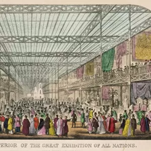
Map to the nightlife of London, 1965

![]()
Wall Art and Photo Gifts from Mary Evans Picture Library
Map to the nightlife of London, 1965
A handdrawn pullout map of Soho, Leicester Square and the West End as far as Hyde Park, showing theatres, cinemas and restaurants in Central London. Intended as a motorists entertainment guide, the map also features garages, one-way streets and car parks. The restaurants were chosen because they specialised in late-night dining.
1966
Mary Evans Picture Library makes available wonderful images created for people to enjoy over the centuries
Media ID 14373828
© Illustrated London News Ltd/Mary Evans
1966 Cinemas Cities Congestion Driving Garages Hyde Jan16 Leicester Maps Motorist Motorists Nightlife Parking Parks Restaurants Soho Theatres Traffic
FEATURES IN THESE COLLECTIONS
> Europe
> United Kingdom
> England
> London
> Art
> Entertainment
> Europe
> United Kingdom
> England
> London
> Art
> Theatre
> Europe
> United Kingdom
> England
> London
> Sights
> Hyde Park
> Europe
> United Kingdom
> England
> London
> Towns
> The Hyde
> Maps and Charts
> Related Images
EDITORS COMMENTS
Step into the vibrant and lively world of London's nightlife in 1965 as depicted in this intricately hand-drawn map. Published by Illustrated London News Ltd, this pullout map invites motorists to explore the bustling streets of Soho, Leicester Square, and the West End, extending as far as Hyde Park. This map serves as a comprehensive guide for those seeking entertainment after dark, featuring an array of theatres, cinemas, and restaurants. The map's meticulous detailing includes not only the locations of these establishments but also essential information for motorists, such as one-way streets, car parks, and garages. The restaurants were carefully selected for their reputation in late-night dining, ensuring a satisfying end to a day spent navigating the congested urban landscape. London's nightlife was a unique blend of culture, entertainment, and the urban experience. The map offers a glimpse into the city's rich history and the allure that drew visitors from near and far. As you delve deeper into the map, you can almost hear the hum of conversation, the laughter, and the sound of music emanating from the various venues. This map is an invaluable resource for those seeking to immerse themselves in the vibrant nightlife of London during the 1960s. It serves as a testament to the city's enduring charm and its ability to captivate and enthrall, even in the midst of the hustle and bustle of urban life. So, buckle up, and let the adventure begin!
MADE IN AUSTRALIA
Safe Shipping with 30 Day Money Back Guarantee
FREE PERSONALISATION*
We are proud to offer a range of customisation features including Personalised Captions, Color Filters and Picture Zoom Tools
SECURE PAYMENTS
We happily accept a wide range of payment options so you can pay for the things you need in the way that is most convenient for you
* Options may vary by product and licensing agreement. Zoomed Pictures can be adjusted in the Cart.