Home > Europe > United Kingdom > England > London > Museums > National Army Museum
Map - Praehagraphy of England

![]()
Wall Art and Photo Gifts from Mary Evans Picture Library
Map - Praehagraphy of England
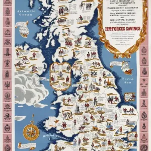
Praehagraphy of England, being a map of that Kingdom illustrative of the principle battles fought in it. Engraved map showing the principle battles fought in England, 55 BC-1745; by the geographer, Mr Wauthier; published by Dichir and Tibett, St James St, London, 23 Jun 1807. Date: 55 BC
Mary Evans Picture Library makes available wonderful images created for people to enjoy over the centuries
Media ID 14389871
© The National Army Museum / Mary Evans Picture Library
1745 Battles Engraved Fought Geographer Illustrative Principle
FEATURES IN THESE COLLECTIONS
> Europe
> United Kingdom
> England
> London
> Museums
> National Army Museum
> Europe
> United Kingdom
> England
> Maps
> Historic
> Battles
> Related Images
EDITORS COMMENTS
This intricately detailed map, titled "Praehagraphy of England," offers a captivating glimpse into the rich historical landscape of England, focusing on the significant battles fought on its soil from 55 BC to 1745. The map, published by Dichir and Tibett in London on June 23, 1807, was the work of the skilled geographer, Mr. Wauthier. The map's title, "Praehagraphy of England," is derived from the Greek words "prae," meaning before, and "graphia," meaning writing or description. This name reflects the map's purpose as an illustrative record of England's military history. The map's intricate design showcases the geographical features of England during this period, with annotations indicating the locations of major battles. Some of the most notable engagements marked on the map include the Battle of Cassivellaunus (54 BC), the Battle of Hastings (1066), the Battle of Agincourt (1415), and the Battle of Culloden (1745). The map's production in 1807, during a time when the study of history was gaining increasing importance, underscores the significance of preserving the past. The Praehagraphy of England serves as a testament to the historical knowledge of its time, providing a visual representation of England's rich military history. The map's intricate details and meticulous annotations offer a fascinating window into the past, inviting viewers to explore the historical events that shaped England's landscape and identity. This beautiful and historic map is a must-have for anyone with an interest in English history, cartography, or the study of military engagements.
MADE IN AUSTRALIA
Safe Shipping with 30 Day Money Back Guarantee
FREE PERSONALISATION*
We are proud to offer a range of customisation features including Personalised Captions, Color Filters and Picture Zoom Tools
SECURE PAYMENTS
We happily accept a wide range of payment options so you can pay for the things you need in the way that is most convenient for you
* Options may vary by product and licensing agreement. Zoomed Pictures can be adjusted in the Cart.