Home > Maps and Charts > Early Maps
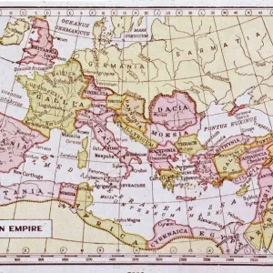
Map / Roman Empire / Cup

![]()
Wall Art and Photo Gifts from Mary Evans Picture Library
Map / Roman Empire / Cup
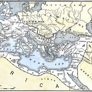
Part of the Roman Empire, showing St Pauls journeys
Mary Evans Picture Library makes available wonderful images created for people to enjoy over the centuries
Media ID 4357661
© Mary Evans Picture Library 2015 - https://copyrighthub.org/s0/hub1/creation/maryevans/MaryEvansPictureID/10114040
FEATURES IN THESE COLLECTIONS
> Europe
> Related Images
> Maps and Charts
> Early Maps
EDITORS COMMENTS
This print showcases a detailed map of the Roman Empire, specifically highlighting St. Paul's journeys throughout the 1st century AD. The intricate design and historical significance of this piece make it a true treasure for any history enthusiast or lover of ancient civilizations.
The map provides a fascinating glimpse into the vast expanse of the Roman Empire during its peak, offering insight into the various regions and territories that made up this powerful civilization. From Europe to parts of Africa and Asia, this map illustrates just how far-reaching and influential the Roman Empire truly was.
In addition to showcasing the expansive reach of Rome, this print also focuses on St. Paul's important travels throughout the empire. As one of Christianity's most prominent figures, St. Paul played a crucial role in spreading the teachings of Jesus Christ across different lands and cultures.
Overall, this print is not only visually stunning but also rich in historical context. It serves as a reminder of the enduring legacy of both the Roman Empire and early Christianity, making it a valuable addition to any collection focused on ancient history or religious studies.
MADE IN AUSTRALIA
Safe Shipping with 30 Day Money Back Guarantee
FREE PERSONALISATION*
We are proud to offer a range of customisation features including Personalised Captions, Color Filters and Picture Zoom Tools
SECURE PAYMENTS
We happily accept a wide range of payment options so you can pay for the things you need in the way that is most convenient for you
* Options may vary by product and licensing agreement. Zoomed Pictures can be adjusted in the Cart.