Home > Europe > United Kingdom > England > Essex > Burnham-On-Crouch
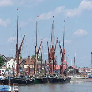
A map showing south-east Essex

![]()
Wall Art and Photo Gifts from Mary Evans Picture Library
A map showing south-east Essex
A map showing south-east Essex. Date: 1903
Mary Evans Picture Library makes available wonderful images created for people to enjoy over the centuries
Media ID 14348657
© Mary Evans / Grenville Collins Postcard Collection
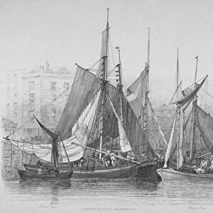
Essex Maldon Sep15 South East Southeast Southeastern Southend Burnham On Crouch
FEATURES IN THESE COLLECTIONS
> Europe
> United Kingdom
> England
> Essex
> Burnham on Crouch
> Europe
> United Kingdom
> England
> Essex
> Burnham-On-Crouch
> Europe
> United Kingdom
> England
> Essex
> Maldon
> Europe
> United Kingdom
> England
> Essex
> Southend-on-Sea
EDITORS COMMENTS
1. Title: A Glance into the Past: A Detailed Map of South-East Essex in 1903 This map print, dated 1903, offers a fascinating glimpse into the geography and topography of South-East Essex, an area rich in history and natural beauty. The map meticulously illustrates the coastline, towns, and villages that once formed the southeasternmost tip of England. The map includes the bustling seaside resort of Southend-on-Sea, with its famous pier and sandy beaches, as well as the historic market town of Maldon, situated on the banks of the River Blackwater. The estuaries of the Thames and Crouch rivers are also depicted, teeming with the bustling ports of Burnham-on-Crouch and Southend. Further inland, the map reveals the undulating landscape of Essex, dotted with quaint villages and picturesque countryside. The expansive Foulness Island, a nature reserve and former military testing ground, is also shown, providing a stark contrast to the urban development along the coast. This map offers a unique perspective into the past, allowing us to explore the history and geography of South-East Essex over a century ago. It serves as a reminder of the rich heritage and natural beauty that continues to attract visitors to this area today. Key locations depicted on the map include: * Southend-on-Sea * Maldon * Burnham-on-Crouch * Foulness Island * The Thames and Crouch Estuaries This map is an invaluable resource for historians, genealogists, and anyone with an interest in the history and geography of South-East Essex. It provides a captivating window into the past, allowing us to explore the region's history and appreciate its enduring charm.
MADE IN AUSTRALIA
Safe Shipping with 30 Day Money Back Guarantee
FREE PERSONALISATION*
We are proud to offer a range of customisation features including Personalised Captions, Color Filters and Picture Zoom Tools
SECURE PAYMENTS
We happily accept a wide range of payment options so you can pay for the things you need in the way that is most convenient for you
* Options may vary by product and licensing agreement. Zoomed Pictures can be adjusted in the Cart.