Home > Oceania > New Zealand > Maps
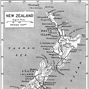
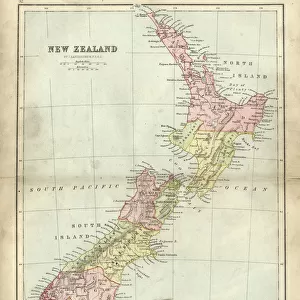
Two maps of Taranaki, New Zealand

![]()
Wall Art and Photo Gifts from Mary Evans Picture Library
Two maps of Taranaki, New Zealand
Two maps of Taranaki, New Zealand showing Middlesex Regiment operations during the Maori War, 1860-1872. From the collection of the former Middlesex Regiment Museum. Date: 1860
Mary Evans Picture Library makes available wonderful images created for people to enjoy over the centuries
Media ID 14389879
© The National Army Museum / Mary Evans Picture Library
1860 1966 Australasia Maori Maps Middlesex Operations Regiment Taranaki Wars Zealand 1921
FEATURES IN THESE COLLECTIONS
> Europe
> United Kingdom
> England
> Middlesex
> Related Images
> Maps and Charts
> Related Images
> Oceania
> New Zealand
> Maps
EDITORS COMMENTS
This intriguing pair of maps offers a unique perspective into the military campaigns of the Middlesex Regiment during the Maori Wars in Taranaki, New Zealand, between 1860 and 1872. The first map, dated 1860, illustrates the initial British military engagement in the region, marking the advance of the 2nd and 3rd Battalions of the Middlesex Regiment under the command of Lieutenant-General Sir Thomas Pratt. The second map, dated 1921, is an updated version showing the progression of the conflict, with the addition of the Duke of Cambridge's Own (Middlesex Regiment) and the 19th Hussars' involvement in the later stages of the war. The Maori Wars were a series of conflicts between the British Crown and various Maori tribes in New Zealand, primarily in the North Island. The Taranaki region became a focal point of the conflict due to its rich agricultural lands and the desire for control over Maori resources. The Middlesex Regiment played a significant role in these campaigns, with numerous engagements taking place in the area. These maps, part of the former Middlesex Regiment Museum's collection, provide valuable insights into the military strategies and tactics employed during this period. The detailed illustrations of fortifications, troop movements, and geographical features offer a captivating glimpse into the complex history of the Maori Wars and the role of the Middlesex Regiment in shaping it. The first map, with its original 1860 date, is a rare find, as most historical records of the Maori Wars focus on later stages of the conflict. The second map, produced in 1921, offers a more comprehensive view of the overall military operations in Taranaki during the Maori Wars. Together, they serve as a testament to the rich military history shared between Australia, New Zealand, and the United Kingdom.
MADE IN AUSTRALIA
Safe Shipping with 30 Day Money Back Guarantee
FREE PERSONALISATION*
We are proud to offer a range of customisation features including Personalised Captions, Color Filters and Picture Zoom Tools
SECURE PAYMENTS
We happily accept a wide range of payment options so you can pay for the things you need in the way that is most convenient for you
* Options may vary by product and licensing agreement. Zoomed Pictures can be adjusted in the Cart.