Home > Europe > Belgium > Maps
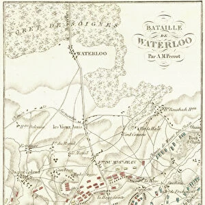
Map of Brussels

![]()
Wall Art and Photo Gifts from Mary Evans Picture Library
Map of Brussels
Map of the city of Brussels, Belgium Date: 19th century
Mary Evans Picture Library makes available wonderful images created for people to enjoy over the centuries
Media ID 7403923
© Mary Evans Picture Library 2015 - https://copyrighthub.org/s0/hub1/creation/maryevans/MaryEvansPictureID/10474594
FEATURES IN THESE COLLECTIONS
> Mary Evans Prints Online
> National Archives
EDITORS COMMENTS
1. Title: A Journey Through Time: Exploring the 19th Century Map of Brussels This antique map print invites us to take a step back in time and explore the city of Brussels as it appeared in the 19th century. Dating back to an era when the city was undergoing significant transformation, this map offers a fascinating glimpse into the urban landscape of Brussels during a period of great change. The intricate details of the map reveal the city's well-planned streets, bustling markets, and historic landmarks. The grandeur of the Royal Palace, the majestic spires of the St. Michael and St. Gudula Cathedral, and the tranquil waters of the Paleisplein Pond are all clearly depicted, providing a sense of the city's rich history and architectural heritage. The map also highlights the various districts and neighborhoods of Brussels, each with its unique character and charm. From the bustling commercial center around the Grand Place to the residential areas surrounding the city center, the map provides a comprehensive overview of the city's layout and topography. As we delve deeper into the map, we can also see the city's fortifications, which once protected Brussels from external threats. The fortifications, which were largely dismantled in the late 19th century, served as a testament to the city's resilience and its ability to adapt to the changing world. This 19th century map of Brussels is not only a valuable historical document but also a beautiful work of art. The intricate details, the use of color, and the overall design make it a fascinating addition to any collection of historical maps or a great conversation piece in a home or office. Whether you are a history buff, an armchair traveler, or simply someone who appreciates the beauty of old maps, this print is sure to captivate and inspire you.
MADE IN AUSTRALIA
Safe Shipping with 30 Day Money Back Guarantee
FREE PERSONALISATION*
We are proud to offer a range of customisation features including Personalised Captions, Color Filters and Picture Zoom Tools
SECURE PAYMENTS
We happily accept a wide range of payment options so you can pay for the things you need in the way that is most convenient for you
* Options may vary by product and licensing agreement. Zoomed Pictures can be adjusted in the Cart.