Home > Historic > Ancient artifacts and relics > Greek sculptures > Portraits of children families
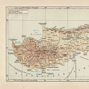
Map of Third Crusade and Childrens Crusade

![]()
Wall Art and Photo Gifts from Mary Evans Picture Library
Map of Third Crusade and Childrens Crusade
Map of the Third Crusade and the Childrens Crusade, showing various routes and territories. Date: 1190
Mary Evans Picture Library makes available wonderful images created for people to enjoy over the centuries
Media ID 23265648
© Mary Evans Picture Library
12th Conflict Crete Cyprus Hungary Invasion Mediterranean Moslem Muslim Power Saladin Sicily Struggle Wars
FEATURES IN THESE COLLECTIONS
> Africa
> Related Images
> Asia
> Cyprus
> Related Images
> Europe
> Italy
> Sicily
> Related Images
> Historic
> Ancient artifacts and relics
> Greek sculptures
> Portraits of children families
> Mary Evans Prints Online
> New Images August 2021
EDITORS COMMENTS
This map print depicts the significant events of the Third Crusade and the Children's Crusade during the 12th century. The Third Crusade, initiated in 1189, was a major European response to the fall of Jerusalem to Saladin, the Muslim sultan. The map illustrates the various routes taken by the crusading armies from Europe, including those led by King Richard I of England, Frederick Barbarossa of Germany, and Philip II of France. The map also highlights the territories of the Eastern Roman Empire, the Holy Land, and the Mediterranean, showcasing the strategic locations of Sicily, Crete, Greece, and Cyprus. The Children's Crusade, an extraordinary event that took place in 1212, is also depicted on this map. Thousands of children, led by two young shepherds, embarked on a journey from Europe with the hope of reaching the Holy Land and liberating it from Muslim rule. Although the outcome of their journey was not as successful as they had hoped, their determination and faith remain an inspiring testament to the spiritual fervor of the era. The map also highlights the power struggles and conflicts between Christian and Muslim forces in the Middle East, as well as the role of key players such as the Byzantine Empire and the Ayyubid Dynasty. This intricately detailed map print offers a captivating glimpse into the rich history of the 12th century, a time marked by religious war, invasion, and the struggle for power and territory in Europe and the Mediterranean.
MADE IN AUSTRALIA
Safe Shipping with 30 Day Money Back Guarantee
FREE PERSONALISATION*
We are proud to offer a range of customisation features including Personalised Captions, Color Filters and Picture Zoom Tools
SECURE PAYMENTS
We happily accept a wide range of payment options so you can pay for the things you need in the way that is most convenient for you
* Options may vary by product and licensing agreement. Zoomed Pictures can be adjusted in the Cart.