Home > Maps and Charts > Early Maps
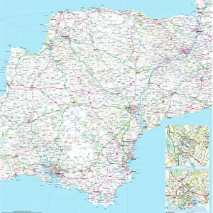
METROLAND MAP

![]()
Wall Art and Photo Gifts from Mary Evans Picture Library
METROLAND MAP
A map of Metro-Land, the residential area in Londons northwest hinterland, served by Londons Underground though in these parts most of it runs over ground. Date: 1926
Mary Evans Picture Library makes available wonderful images created for people to enjoy over the centuries
Media ID 23032692
© Mary Evans Picture Library
Area Communities Community Londons Metro Northwest Parts Planning Residential Runs Served Towns Underground 1926 Hinterland
FEATURES IN THESE COLLECTIONS
> Europe
> United Kingdom
> England
> London
> Related Images
> Maps and Charts
> Early Maps
> Mary Evans Prints Online
> New Images August 2021
EDITORS COMMENTS
1. Title: "Metro-Land: A 1926 Map Unveiling the Planned Residential Communities of London's Northwest Hinterland" This black-and-white print showcases the Metro-Land Map, a historical document that offers a glimpse into the meticulously planned residential communities in the northwest hinterland of London, England, which were served primarily by the London Underground, with most of the transport system running above ground. Dated 1926, this map illustrates the intricate network of towns and communities that emerged as a result of forward-thinking urban planning. Metro-Land was an ambitious project initiated by the Metropolitan Railway Company to develop a suburban extension of London, offering affordable housing and easy access to the city center via the Underground. The map reveals the extensive reach of the railway lines, connecting various towns and communities such as Wembley, Harrow, and Watford, among others. The residential areas, carefully planned and designed, were intended to provide a desirable living environment for Londoners seeking a more tranquil and spacious lifestyle. The map's intricate details reveal the layout of the towns, including their roads, parks, and other amenities. The meticulous planning is evident in the evenly spaced housing developments, green spaces, and the proximity of each community to the railway stations. This map serves as a testament to the visionary urban planning that shaped the London suburbs during the early 20th century and continues to influence the city's development to this day. In conclusion, this 1926 Metro-Land Map is a fascinating historical artifact that offers a unique perspective on the evolution of London's suburban communities. It showcases the meticulous planning and innovative transportation system that made these residential areas an attractive alternative to the congested city center, shaping the way Londoners lived, worked, and commuted for generations.
MADE IN AUSTRALIA
Safe Shipping with 30 Day Money Back Guarantee
FREE PERSONALISATION*
We are proud to offer a range of customisation features including Personalised Captions, Color Filters and Picture Zoom Tools
SECURE PAYMENTS
We happily accept a wide range of payment options so you can pay for the things you need in the way that is most convenient for you
* Options may vary by product and licensing agreement. Zoomed Pictures can be adjusted in the Cart.