Home > North America > United States of America > New York > New York > Maps
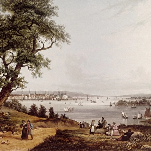
View of New York City 1849 and Waterways Date: 1849

![]()
Wall Art and Photo Gifts from Mary Evans Picture Library
View of New York City 1849 and Waterways Date: 1849
Mary Evans Picture Library makes available wonderful images created for people to enjoy over the centuries
Media ID 20247525
© Pictures Now Image Collection / Bubblepunk
1849 Antiquarian Antique Harbors Journey Journeys Maps Travels Treks Trip Trips Voyage Voyages Waterways
FEATURES IN THESE COLLECTIONS
> Mary Evans Prints Online
> Pictures Now
> North America
> United States of America
> Maps
> North America
> United States of America
> New York
> New York
> Maps
EDITORS COMMENTS
Step back in time with this 1849 print of New York City, showcasing the bustling metropolis as it once was. The image, titled "View of New York City and Waterways Date: 1849," offers a unique perspective of the city before its transformation into the modern-day urban jungle. The antiquarian map reveals the intricate network of waterways that once surrounded New York, including the Hudson and East Rivers, and the harbor teeming with ships from across the globe. The Empire State and other nearby states are depicted in fine detail, highlighting the importance of New York as a major hub for trade and commerce in the United States. This print invites us to imagine the journeys and travels that once took place on these waters. Sailors and merchants embarked on voyages from Europe, Asia, and South America, bringing with them new ideas, goods, and cultures that shaped the young American nation. The print serves as a reminder of the rich history and diverse heritage that New York City has embodied since its early days. The intricate lines and precise detail of the map reflect the meticulous craftsmanship of the antique print, transporting us back to a time when exploration and discovery were at the heart of human endeavor. Whether you're an history buff, a collector of antique maps, or simply someone who appreciates the beauty of the past, this print is a must-have addition to your collection.
MADE IN AUSTRALIA
Safe Shipping with 30 Day Money Back Guarantee
FREE PERSONALISATION*
We are proud to offer a range of customisation features including Personalised Captions, Color Filters and Picture Zoom Tools
SECURE PAYMENTS
We happily accept a wide range of payment options so you can pay for the things you need in the way that is most convenient for you
* Options may vary by product and licensing agreement. Zoomed Pictures can be adjusted in the Cart.