Home > North America > Mexico > Maps
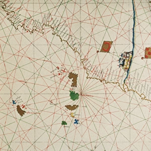
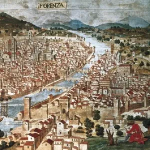
Portolan chart, 1591. Map of the Pacific Ocean

![]()
Wall Art and Photo Gifts from Mary Evans Picture Library
Portolan chart, 1591. Map of the Pacific Ocean
Portolan chart, 1591. Map of the Pacific Ocean. It depicts the western coast of Central and South America, from Mexico to the Strait of Magellan. Renaissance art. Miniature Painting
Mary Evans Picture Library makes available wonderful images created for people to enjoy over the centuries
Media ID 8276413
© Mary Evans Picture Library 2015 - https://copyrighthub.org/s0/hub1/creation/maryevans/MaryEvansPictureID/10683499
Chart Depicts Economic Illuminated Magellan Manuscript Manuscripts Mexico Miniatures Pacific Portolan Renaissance Strait Tropic Tropical
FEATURES IN THESE COLLECTIONS
> Arts
> Art Movements
> Renaissance Art
> North America
> Mexico
> Maps
> South America
> Related Images
EDITORS COMMENTS
This exquisite Portolan chart, created in 1591, presents a captivating depiction of the Pacific Ocean and the western coasts of Central and South America. The map stretches from Mexico in the north to the Strait of Magellan in the south, offering a glimpse into the European understanding of the world during the Renaissance period. The intricately detailed chart is a miniature painting, showcasing the tropical regions with meticulous accuracy and vibrant colors. The Portolan chart is an important contribution to the cartographic tradition, representing a significant advancement in the representation of the world's oceans. The chart's illuminated design, with its elegant borders and ornate decorations, speaks to the artistic and intellectual achievements of the time. The Pacific Ocean, a vast and mysterious body of water, was still largely unexplored during the 16th century. This map, with its depiction of the coastlines and ocean currents, would have provided valuable information to navigators and explorers setting out on voyages of discovery. The chart's intricate details, from the winding rivers to the jagged coastlines, attest to the painstaking efforts of the cartographer and the dedication of the manuscript's creator. The Portolan chart is a testament to the European fascination with the New World and the desire to explore and chart the unknown. Its intricate design and meticulous detail make it a beautiful and fascinating piece of Renaissance art and a valuable historical document.
MADE IN AUSTRALIA
Safe Shipping with 30 Day Money Back Guarantee
FREE PERSONALISATION*
We are proud to offer a range of customisation features including Personalised Captions, Color Filters and Picture Zoom Tools
SECURE PAYMENTS
We happily accept a wide range of payment options so you can pay for the things you need in the way that is most convenient for you
* Options may vary by product and licensing agreement. Zoomed Pictures can be adjusted in the Cart.