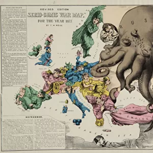
Serio-comic war map for the year 1877

![]()
Wall Art and Photo Gifts from Mary Evans Picture Library
Serio-comic war map for the year 1877
Mary Evans Picture Library makes available wonderful images created for people to enjoy over the centuries
Media ID 7276293
© Mary Evans Picture Library 2015 - https://copyrighthub.org/s0/hub1/creation/maryevans/MaryEvansPictureID/10600278
The Serio-Comic War Map for the Year 1877 - A Humorous yet Insightful Look into the Political Landscape of Europe
EDITORS COMMENTS
This intriguing map print, dating back to the year 1877, offers a unique and entertaining perspective on the political landscape of Europe during that time. The map, titled "The Serio-Comic War Map for the Year 1877," is a masterpiece of serio-comic art that combines elements of humor and accuracy to create an engaging and informative visual representation of Europe's political situation. The map is adorned with whimsical illustrations and playful annotations that poke fun at the various political alliances, conflicts, and power struggles that defined Europe in the late 19th century. From the "Grand Duchy of Bavaria-Bavaria" to the "Kingdom of Belgium-Mecklenburg," the map's labels are filled with clever puns and humorous references that add a lighthearted touch to the otherwise complex and often contentious political landscape. Despite its playful nature, the map is also a remarkably accurate reflection of the political realities of the time. It depicts the various European powers and their territories with great detail, and highlights the numerous conflicts and tensions that existed between them. The map also includes key events of the time, such as the Russo-Turkish War and the unification of Italy, adding an educational dimension to the piece. This serio-comic war map for the year 1877 is a fascinating glimpse into the past, offering a unique perspective on the political landscape of Europe during a time of great change and upheaval. Its combination of humor and historical accuracy makes it a must-see for anyone interested in European history, cartography, or the art of satire. The map is a testament to the power of visual storytelling and the enduring appeal of a good joke. It invites us to look at history in a new light, and reminds us that even in the most serious of times, there is always room for a little laughter and levity.
MADE IN AUSTRALIA
Safe Shipping with 30 Day Money Back Guarantee
FREE PERSONALISATION*
We are proud to offer a range of customisation features including Personalised Captions, Color Filters and Picture Zoom Tools
SECURE PAYMENTS
We happily accept a wide range of payment options so you can pay for the things you need in the way that is most convenient for you
* Options may vary by product and licensing agreement. Zoomed Pictures can be adjusted in the Cart.