Home > Europe > Norway > Maps
Strategic factors in the north by G. H. Davis

![]()
Wall Art and Photo Gifts from Mary Evans Picture Library
Strategic factors in the north by G. H. Davis
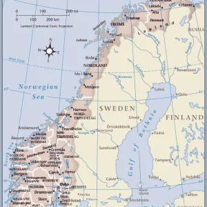
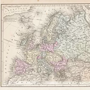
Strategic factors in the north: Swedish iron ore; Norways coast. A pictorial map of Scandinavia, showing the iron fields and their ports of shipment, the route from Narvik to Germany through Norwegian waters, and Allied minefields.
1940
Mary Evans Picture Library makes available wonderful images created for people to enjoy over the centuries
Media ID 14132763
© Illustrated London News Ltd/Mary Evans
Allied Baltic Davis Export Factors Fields Iron Narvik Norwegian Pictorial Ports Route Routes Scandinavia Shipment Strategic Sweden Swedish Waters
FEATURES IN THESE COLLECTIONS
> Maps and Charts
> World
Strategic Factors in the North - A Visual Examination of Sweden's Iron Ore and Norway's Coastline During World War II
EDITORS COMMENTS
This evocative and historically significant image, titled "Strategic Factors in the North: Swedish Iron Ore; Norways Coast. A Pictorial Map of Scandinavia," was published in the Illustrated London News in 1940. The map, created by renowned cartographer G.H. Davis, offers a compelling visual representation of the strategic importance of Scandinavia during the early years of World War II. At the heart of this map lies Sweden's extensive iron ore fields and the ports through which this vital resource was shipped. The iron ore deposits in Sweden were a critical asset for the Axis powers, particularly Germany, which relied heavily on this mineral for its war efforts. The map highlights the key ports of Luleå, Malmö, and Gävle, which were essential for exporting the iron ore to Germany via the Baltic Sea. The map also illustrates the route from Narvik, Norway, to Germany, which passed through Norwegian waters. This route was a significant shipping lane during the war, as it provided the shortest and most direct sea link between Germany and the iron ore fields of Sweden. However, it was also a highly contested area, as the Allies sought to disrupt Axis supply lines by laying minefields in the waters around Norway. This map offers a unique perspective on the strategic factors at play in the North during World War II. It underscores the importance of natural resources, shipping routes, and maritime control in the conflict, as well as the role of cartography in shaping our understanding of historical events. The image is a poignant reminder of the complex geopolitical dynamics that shaped the Second World War and the vital role that Scandinavia played in the conflict.
MADE IN AUSTRALIA
Safe Shipping with 30 Day Money Back Guarantee
FREE PERSONALISATION*
We are proud to offer a range of customisation features including Personalised Captions, Color Filters and Picture Zoom Tools
SECURE PAYMENTS
We happily accept a wide range of payment options so you can pay for the things you need in the way that is most convenient for you
* Options may vary by product and licensing agreement. Zoomed Pictures can be adjusted in the Cart.