Home > Europe > United Kingdom > England > London > Boroughs > Bexley
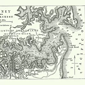
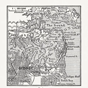
Sydney, Australia - Map of Sydney and Port Jackson

![]()
Wall Art and Photo Gifts from Mary Evans Picture Library
Sydney, Australia - Map of Sydney and Port Jackson
Slide showing a map of Sydney and Port Jackson, with the areas of the city labelled.. Boswell Collection. Slide number 5. Sydney is the most populous city in Australia and the state capital of New South Wales. It is located on Australias south-east coast of the Tasman Sea. Date: circa 1890s
Mary Evans Picture Library makes available wonderful images created for people to enjoy over the centuries
Media ID 14172966
© The Boswell Collection, Bexley Heritage Trust / Mary Evans
Areas Australian Capital Jackson Labelled Slides Sydney
FEATURES IN THESE COLLECTIONS
> Europe
> United Kingdom
> England
> London
> Boroughs
> Bexley
> Europe
> United Kingdom
> Wales
> Maps
> Maps and Charts
> Early Maps
> Maps and Charts
> Wales
> Oceania
> Australia
> Sydney
EDITORS COMMENTS
This lantern slide presents a detailed map of Sydney, Australia, and Port Jackson from the late 19th century. Dating back to approximately the 1890s, this map is an essential historical record of the city during a pivotal period in its development. Sydney, the most populous city in Australia and the capital of New South Wales, is situated on the south-east coast of the Tasman Sea. The map meticulously outlines the various areas of the city, including Circular Quay, The Rocks, Darling Harbour, and Balmain. Port Jackson, the natural harbor that cradles Sydney, is also clearly marked on the map. The harbor's strategic location and abundant resources played a significant role in Sydney's growth as a major trading hub and naval base. The map also reveals the city's early urban planning, with the grid-like street layout and the presence of parks and public spaces. This exquisite slide is part of the Boswell Collection, slide number 5, and serves as a fascinating glimpse into the history of Sydney during the late 19th century. The intricate details of the map offer valuable insights into the city's geography, infrastructure, and development during this period. As you explore the labeled areas, you can almost hear the bustling sounds of the busy port and the lively energy of Sydney's early inhabitants. This historical artifact invites us to delve deeper into the rich history of one of the world's most beloved and vibrant cities.
MADE IN AUSTRALIA
Safe Shipping with 30 Day Money Back Guarantee
FREE PERSONALISATION*
We are proud to offer a range of customisation features including Personalised Captions, Color Filters and Picture Zoom Tools
SECURE PAYMENTS
We happily accept a wide range of payment options so you can pay for the things you need in the way that is most convenient for you
* Options may vary by product and licensing agreement. Zoomed Pictures can be adjusted in the Cart.