Home > Africa > Tunisia > Maps
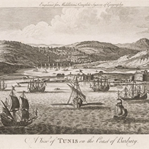
Tunis commanding Sicilian Channel by G. H. Davis

![]()
Wall Art and Photo Gifts from Mary Evans Picture Library
Tunis commanding Sicilian Channel by G. H. Davis
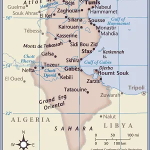
Tunis, which with Bizerta commands the Sicilian Channel. A contour map showing the capital of Tunisia, its approaches, roads, harbour and surrounding terrain. A strategic location during the Second World War. Date: 1942
Mary Evans Picture Library makes available wonderful images created for people to enjoy over the centuries
Media ID 14133355
© Illustrated London News Ltd/Mary Evans
1942 Approach Approaches Capital Channel Commanding Commands Contour Davis Gulf Maps Roads Sicilian Sicily Strategic Surrounding Terrain Tunis Tunisia Tunisian
FEATURES IN THESE COLLECTIONS
> Africa
> Tunisia
> Lakes
> Related Images
> Europe
> Italy
> Sicily
> Related Images
> Maps and Charts
> Early Maps
> Maps and Charts
> World
Tunis - Commanding the Sicilian Channel, a Strategic Location during the Second World War
EDITORS COMMENTS
In this evocative photograph, the capital city of Tunis, Tunisia, takes center stage, commanding the Sicilian Channel with an air of authority. The image, captured by renowned photographer G.H. Davis in 1942, offers a glimpse into the strategic importance of this North African city during wartime. The contour map in the foreground provides context to the scene, highlighting the city's approaches, roads, harbor, and surrounding terrain. Tunis, with its position at the Lake of Tunis, sits proudly at the entrance to the Mediterranean Sea, controlling access to the Sicilian Channel and the Gulf of Tunis. This location made it a crucial strategic point during the Second World War, particularly for the Allied forces seeking to defend against Axis powers. As the capital of Tunisia, Tunis held significant political and economic importance. Its well-developed infrastructure, including roads and harbors, facilitated the movement of troops and supplies. The city's harbor, visible in the map, allowed for the easy transportation of goods and military equipment. The terrain surrounding Tunis, depicted in the map, features rolling hills and rugged coastline, making it a challenging yet defensible location. The city's natural defenses, combined with its strategic position, made it a formidable fortress during the war. This photograph, with its historical significance and stunning composition, offers a unique perspective into the past. It serves as a reminder of the rich history and strategic importance of Tunis and its role during the Second World War.
MADE IN AUSTRALIA
Safe Shipping with 30 Day Money Back Guarantee
FREE PERSONALISATION*
We are proud to offer a range of customisation features including Personalised Captions, Color Filters and Picture Zoom Tools
SECURE PAYMENTS
We happily accept a wide range of payment options so you can pay for the things you need in the way that is most convenient for you
* Options may vary by product and licensing agreement. Zoomed Pictures can be adjusted in the Cart.