Fraud Blocker Skip to main content

Home > North America > Canada > Maps

Maps Collection (page 8)

Maps of Canada North America are a great way to explore the vastness and beauty of this region

846 items

Background imageMaps Collection: Map of Lake Ontario with the English and French fleets, 1757 (engraving)

Map of Lake Ontario with the English and French fleets, 1757 (engraving)
3058240 Map of Lake Ontario with the English and French fleets, 1757 (engraving) by French School, (18th century); Private Collection; (add.info)

Background imageMaps Collection: Humfray Gylbert knight his charte, c. 1582 (vellum)

Humfray Gylbert knight his charte, c. 1582 (vellum)
660771 Humfray Gylbert knight his charte, c.1582 (vellum) by Dee, John (1527-1609); 50x62 cm; Free Library of Philadelphia; (add.info.: Sir Humphrey Gilbert (c)

Background imageMaps Collection: The North Atlantic Telegraph (engraving)

The North Atlantic Telegraph (engraving)
1612257 The North Atlantic Telegraph (engraving) by English School, (19th century); Private Collection; (add.info.: The North Atlantic Telegraph)

Background imageMaps Collection: Map showing the Position of the Island of San Juan (engraving)

Map showing the Position of the Island of San Juan (engraving)
1098289 Map showing the Position of the Island of San Juan (engraving) by English School, (19th century); Private Collection; (add.info.: Map showing the Position of the Island of San Juan)

Background imageMaps Collection: The Lake Frontier of Canada and the United States (coloured engraving)

The Lake Frontier of Canada and the United States (coloured engraving)
3062955 The Lake Frontier of Canada and the United States (coloured engraving) by English School, (19th century); National Army Museum

Background imageMaps Collection: View of Quebec City in Canada (late 17th century): A. Jardin du fort. B. The fort. C

View of Quebec City in Canada (late 17th century): A. Jardin du fort. B. The fort. C
XEE4134580 View of Quebec City in Canada (late 17th century): A. Jardin du fort. B. The fort. C. Powder store. D. Les Recollets. E. Ursulines. F. The Jesuites. G. The cathedrale. H. The seminar. I

Background imageMaps Collection: Economic maps of Canada (colour litho)

Economic maps of Canada (colour litho)
6025443 Economic maps of Canada (colour litho) by English School, (20th century); Private Collection; (add.info.: Economic maps of Canada)

Background imageMaps Collection: Nova Scotia and Newfoundland, from a Series of World Maps published by John Tallis & Co

Nova Scotia and Newfoundland, from a Series of World Maps published by John Tallis & Co
STC190610 Nova Scotia and Newfoundland, from a Series of World Maps published by John Tallis & Co. New York & London, 1850s (engraving) by Rapkin

Background imageMaps Collection: ia. A Plan of the Harbour of St Johns in Newfoundland, 1760s (pen & ink and wash)

ia. A Plan of the Harbour of St Johns in Newfoundland, 1760s (pen & ink and wash)
5670245 ia. A Plan of the Harbour of St Johns in Newfoundland, 1760s (pen & ink and wash) by Cook, James (1728-79); Mitchell Library, State Library of New South Wales; (add.info.: Original Sketches)

Background imageMaps Collection: Isobars and Isohyets, United States and Canada (colour litho)

Isobars and Isohyets, United States and Canada (colour litho)
6015865 Isobars and Isohyets, United States and Canada (colour litho) by English School, (19th century); Private Collection; (add.info.: Isobars and Isohyets, United States and Canada)

Background imageMaps Collection: Geographic map of the 17th century Dutch Atlas by Wilhelm Blaeu (1571-1638

Geographic map of the 17th century Dutch Atlas by Wilhelm Blaeu (1571-1638
GIA4790968 Geographic map of the 17th century Dutch Atlas by Wilhelm Blaeu (1571-1638) showing American and Canadian territories fur animal peoples. The North is below according to medieval custom

Background imageMaps Collection: Map of Canada and Greenland (etching, 1730)

Map of Canada and Greenland (etching, 1730)
LRI4706965 Map of Canada and Greenland (etching, 1730) by Delisle, Guillaume (1675-1726); Private Collection; (add.info.: Map of Canada)

Background imageMaps Collection: The Quater-Centenary of Newfoundland (engraving)

The Quater-Centenary of Newfoundland (engraving)
1597540 The Quater-Centenary of Newfoundland (engraving) by English School, (19th century); Private Collection; (add.info.: The Quater-Centenary of Newfoundland)

Background imageMaps Collection: Map of the Boundary between Great Britain and America, as fixed by Lord Ashburtons Treaty

Map of the Boundary between Great Britain and America, as fixed by Lord Ashburtons Treaty (engraving)
1587010 Map of the Boundary between Great Britain and America, as fixed by Lord Ashburtons Treaty (engraving) by English School

Background imageMaps Collection: Isaac Abrahamsz Massa, 1626 (oil on canvas)

Isaac Abrahamsz Massa, 1626 (oil on canvas)
996201 Isaac Abrahamsz Massa, 1626 (oil on canvas) by Hals, Frans (1582/3-1666); 79.7x65.1 cm; Art Gallery of Ontario, Toronto

Background imageMaps Collection: Powder horn, engraved with a map of the St. Lawrence River in the area of Quebec, c

Powder horn, engraved with a map of the St. Lawrence River in the area of Quebec, c
997377 Powder horn, engraved with a map of the St. Lawrence River in the area of Quebec, c.1759 (horn) (see also 997378-80) by Canadian School

Background imageMaps Collection: A Canadian Photographic Reconnaissance pilot examines a picture of Hamburg

A Canadian Photographic Reconnaissance pilot examines a picture of Hamburg. Picture taken 30th August 1943. The Allied bombing of Hamburg during World War II included numerous attacks on civilians

Background imageMaps Collection: Canada northwest provinces map 1898

Canada northwest provinces map 1898
Map from the Complete Handy Atlas of the World - 1898

Background imageMaps Collection: Antique map: Canada

Antique map: Canada

Background imageMaps Collection: Map of Canada 1898

Map of Canada 1898
Map from Physical Geography by R. S. Tarr - The MacMillan Company - London 1898

Background imageMaps Collection: Map of North America, showing the... positions of Texas and Oregon with the United States

Map of North America, showing the... positions of Texas and Oregon with the United States
Map of North America, showing the relative positions of Texas and Oregon with the United States, 1845. It may...be requisite to subjoin here a few leading details of the Oregon Territory

Background imageMaps Collection: Map of the Americas 1685 Date: 1685

Map of the Americas 1685 Date: 1685

Background imageMaps Collection: Warrington WA2 0 Map

Warrington WA2 0 Map
Postcode Sector Map of Warrington WA2 0

Background imageMaps Collection: Hammersmith and Fulham W12 7 Map

Hammersmith and Fulham W12 7 Map
Postcode Sector Map of Hammersmith and Fulham W12 7

Background imageMaps Collection: Rother TN39 4 Map

Rother TN39 4 Map
Postcode Sector Map of Rother TN39 4

Background imageMaps Collection: Southwark SE16 7 Map

Southwark SE16 7 Map
Postcode Sector Map of Southwark SE16 7

Background imageMaps Collection: Southampton SO19 9 Map

Southampton SO19 9 Map
Postcode Sector Map of Southampton SO19 9

Background imageMaps Collection: South Buckinghamshire SL1 1 Map

South Buckinghamshire SL1 1 Map
Postcode Sector Map of South Buckinghamshire SL1 1

Background imageMaps Collection: Kennet SN10 4 Map

Kennet SN10 4 Map
Postcode Sector Map of Kennet SN10 4

Background imageMaps Collection: Vale of White Horse SN7 8 Map

Vale of White Horse SN7 8 Map
Postcode Sector Map of Vale of White Horse SN7 8

Background imageMaps Collection: Ealing W3 0 Map

Ealing W3 0 Map
Postcode Sector Map of Ealing W3 0

Background imageMaps Collection: Wychavon WR10 3 Map

Wychavon WR10 3 Map
Postcode Sector Map of Wychavon WR10 3

Background imageMaps Collection: Reigate and Banstead RH1 5 Map

Reigate and Banstead RH1 5 Map
Postcode Sector Map of Reigate and Banstead RH1 5

Background imageMaps Collection: Test Valley SO51 6 Map

Test Valley SO51 6 Map
Postcode Sector Map of Test Valley SO51 6

Background imageMaps Collection: Lewisham SE13 6 Map

Lewisham SE13 6 Map
Postcode Sector Map of Lewisham SE13 6

Background imageMaps Collection: Lewisham SE6 3 Map

Lewisham SE6 3 Map
Postcode Sector Map of Lewisham SE6 3

Background imageMaps Collection: Cherwell OX16 2 Map

Cherwell OX16 2 Map
Postcode Sector Map of Cherwell OX16 2

Background imageMaps Collection: West Norfolk PE31 7 Map

West Norfolk PE31 7 Map
Postcode Sector Map of West Norfolk PE31 7

Background imageMaps Collection: Sussex PO21 1 Map

Sussex PO21 1 Map
Postcode Sector Map of Sussex PO21 1

Background imageMaps Collection: Sussex PO20 0 Map

Sussex PO20 0 Map
Postcode Sector Map of Sussex PO20 0

Background imageMaps Collection: Norfolk NR27 9 Map

Norfolk NR27 9 Map
Postcode Sector Map of Norfolk NR27 9

Background imageMaps Collection: Enfield N18 1 Map

Enfield N18 1 Map
Postcode Sector Map of Enfield N18 1

Background imageMaps Collection: Lincoln LN7 6 Map

Lincoln LN7 6 Map
Postcode Sector Map of Lincoln LN7 6

Background imageMaps Collection: Medway ME7 2 Map

Medway ME7 2 Map
Postcode Sector Map of Medway ME7 2

Background imageMaps Collection: Leicester LE17 4 Map

Leicester LE17 4 Map
Postcode Sector Map of Leicester LE17 4

Background imageMaps Collection: Manchester M40 8 Map

Manchester M40 8 Map
Postcode Sector Map of Manchester M40 8

Background imageMaps Collection: North Kesteven LN4 4 Map

North Kesteven LN4 4 Map
Postcode Sector Map of North Kesteven LN4 4

Background imageMaps Collection: Leeds LS19 6 Map

Leeds LS19 6 Map
Postcode Sector Map of Leeds LS19 6


All Professionally Made to Order for Quick Shipping


-

Maps Collection

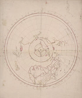
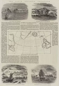
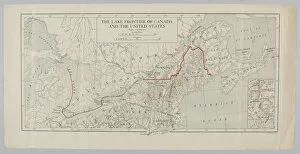
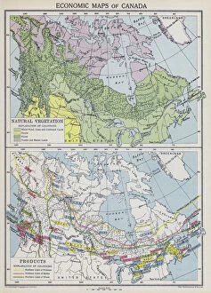
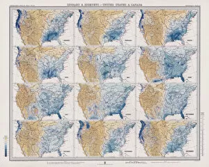
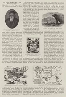
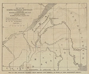
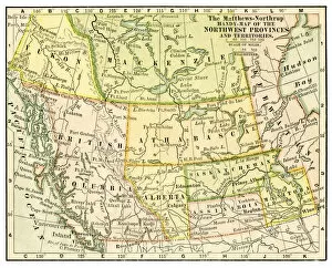
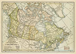
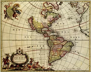
Maps of Canada North America are a great way to explore the vastness and beauty of this region. They provide an overview of the geography, topography, and political boundaries that make up this part of the world. It also show major cities, rivers, lakes, mountains, national parks and other points of interest and can be used for navigation purposes or simply to appreciate the natural beauty that exists in Canada North America. With detailed maps available online or in print form it is easy to find out more about this region and plan trips accordingly and can an invaluable tool for anyone looking to explore all that Canada North America has to offer.
+

Our beautiful pictures are available as Framed Prints, Photos, Wall Art and Photo Gifts

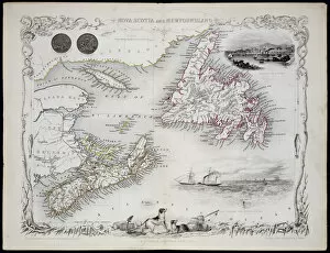
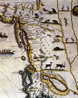
Media Storehouse offers a collection of Maps of Canada North America that showcases the geography, history and culture of this vast region. Our collection features an extensive range of maps dating back to the 16th century, including antique maps from renowned cartographers such as Gerard Mercator and Abraham Ortelius. These historic maps provide a fascinating insight into how early explorers perceived the landmasses and waterways that make up Canada and North America. In addition to these vintage maps, Media Storehouse also offers contemporary versions that highlight modern-day cities, landmarks and natural wonders. These high-quality prints are available in various sizes and formats, including canvas prints, framed prints or posters. Whether you're looking for a unique piece of wall art for your home or seeking inspiration for your next adventure across Canada or North America, our Maps of Canada North America collection is sure to captivate your imagination with its rich history and stunning visuals.
+

What are Maps of Canada North America art prints?

Maps of Canada North America art prints are high-quality reproductions of historical and contemporary maps that depict the geography, topography, and political boundaries of Canada and North America. These art prints showcase the intricate details and artistic styles used by cartographers throughout history to create these important navigational tools. These maps provide a fascinating glimpse into the evolution of geographic knowledge over time, from early explorers' crude sketches to modern satellite imagery. We also offer insight into how borders have shifted over time due to political changes or territorial disputes. Whether you're a history buff, geography enthusiast, or simply looking for a unique piece of wall decor, Maps of Canada North America art prints are an excellent choice. With their rich colors and intricate details, they make great conversation starters in any room. Plus, they can be framed in a variety of styles to match your decor preferences.
+

What Maps of Canada North America art prints can I buy from Media Storehouse?

We offer a wide range of Maps of Canada North America art prints that you can buy. These maps showcase the geographical features, topography, and political boundaries of Canada and North America in stunning detail. You can choose from vintage or contemporary styles, with options ranging from antique maps to modern satellite imagery. Some popular choices include detailed road maps that highlight major highways and cities across the country, as well as topographic maps that show elevation changes and natural landmarks like mountains and rivers. There are also historical maps depicting important events such as explorations or battles. In addition to traditional paper prints, Media Storehouse also offers canvas prints for a more textured look. These high-quality reproductions are perfect for adding a touch of sophistication to any home or office decor. Whether you're looking for a unique gift idea or simply want to decorate your own space with beautiful artwork, we have an extensive selection of Maps of Canada North America art prints to choose from.
+

How do I buy Maps of Canada North America art prints?

To buy Maps of Canada North America art prints from Media Storehouse, you can browse our extensive collection online. The website offers a wide range of maps in different styles and sizes to suit your preferences. You can search for specific locations or themes using the search bar on the homepage or explore the various categories available. Once you have found a map that catches your eye, simply select the size and framing options you prefer before adding it to your cart. The checkout process is straightforward, and you will be prompted to enter your shipping and payment details. We offer high-quality prints that are perfect for home decor or as gifts for friends and family who love geography or travel. Their selection includes vintage maps, topographical maps, political maps, and more. Buying Maps of Canada North America art prints from Media Storehouse is an easy process that allows you to add beautiful pieces of artwork to your home with just a few clicks.
+

How much do Maps of Canada North America art prints cost?

Maps of Canada and North America art prints are available at Media Storehouse. The cost of these prints varies depending on the size, material, and framing options chosen by the customer. However, you can rest assured that they will receive high-quality prints that showcase intricate details of maps in stunning colors. We offer a wide range of map art prints to suit different preferences and budgets. You can choose from various sizes such as small, medium, large or extra-large to fit their space requirements. Additionally, there are different materials available for printing including canvas or paper. Framing options include black frames with white mounts or natural wood frames with cream mounts. These framing options add an elegant touch to the artwork while protecting it from damage. Maps of Canada and North America art prints from Media Storehouse offer excellent value for money considering their quality and customization options available to customers.
+

How will my Maps of Canada North America art prints be delivered to me?

Your Maps of Canada North America art prints will be delivered to you through a reliable and secure delivery service. The company takes pride in ensuring that your order is carefully packaged and shipped to your preferred location. Your art prints will be rolled up and placed inside a sturdy tube, which protects them from any damage during transit. The tube is then sealed with protective caps at both ends to ensure that the contents remain intact. The delivery process is efficient, and you can track your package using the tracking number provided by the company once it has been dispatched. You can expect your Maps of Canada North America art prints to arrive in excellent condition within a reasonable time frame, depending on your location. Media Storehouse values customer satisfaction; hence they strive to deliver quality products while ensuring that their customers receive their orders promptly and securely.