
Maps Collection
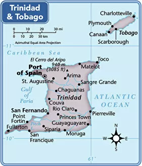
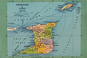
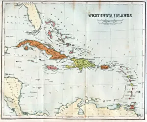
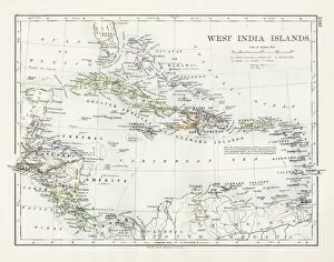
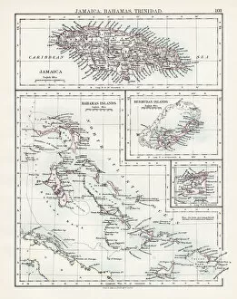
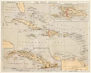
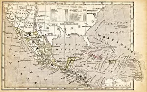
Maps of Trinidad and Tobago North America are detailed maps that show the two islands in the Caribbean Sea
Choose a picture from our Maps Collection for your Wall Art and Photo Gifts
21 items


All Professionally Made to Order for Quick Shipping
-
Maps Collection
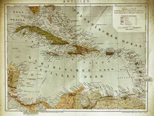
Maps of Trinidad and Tobago North America are detailed maps that show the two islands in the Caribbean Sea. The maps include physical features such as mountains, rivers, lakes, and coastlines. They also show cities and towns, roads, airports, railways and other transportation routes. Additionally they provide information about population density and land use for each island. Maps of Trinidad and Tobago North America are essential for anyone planning to visit or live in either island as they provide an overview of the geography of both islands and can also be used to plan trips around the country or to find specific locations within it.
+
Our beautiful pictures are available as Framed Prints, Photos, Wall Art and Photo Gifts
Media Storehouse offers a collection of Maps of Trinidad and Tobago North America, which includes wall art and framed prints. Our collection features vintage maps that showcase the geography, topography, and landmarks of the two islands in the Caribbean. These maps are sourced from various archives around the world and have been carefully restored to their original condition. The Maps of Trinidad and Tobago North America collection provides an opportunity for history buffs, travelers, or anyone interested in cartography to own a piece of unique artwork that reflects the rich cultural heritage of these islands. Our collection is available in different sizes and formats to suit individual preferences. Whether it's for personal use or as a gift for someone special, our Maps of Trinidad and Tobago North America collection offers a glimpse into the past while celebrating the beauty and diversity of these two Caribbean nations.
+
What are Maps of Trinidad and Tobago North America art prints?
Maps of Trinidad and Tobago North America art prints are high-quality reproductions of maps that depict the geography, topography, and political boundaries of the twin-island nation located in the southern Caribbean. These art prints showcase the intricate details of Trinidad and Tobago's terrain, including its mountains, rivers, forests, coastlines, and towns. These maps also provide a historical perspective on how Trinidad and Tobago evolved over time as a British colony before gaining independence in 1962. We offer valuable insights into the country's cultural diversity, economic development, and geopolitical significance in the region. Whether you're a history buff or an avid traveler who wants to explore every nook and cranny of this beautiful country from afar, Maps of Trinidad and Tobago North America art prints are an excellent choice for your home decor or office space. With their vibrant colors and stunning accuracy, these maps will surely captivate your imagination while adding a touch of sophistication to any room.
+
What Maps of Trinidad and Tobago North America art prints can I buy from Media Storehouse?
We offer a wide range of Maps of Trinidad and Tobago North America art prints that are perfect for decorating your home or office. You can choose from a variety of styles, including vintage maps, modern designs, and satellite images. These prints come in various sizes to fit any space you have available. One popular option is the Vintage Map of Trinidad and Tobago, which features intricate details and beautiful colors that will add character to any room. Another great choice is the Satellite Image Map of Trinidad and Tobago, which showcases the islands' natural beauty from above. Whether you're looking for something traditional or contemporary, we have plenty of options to suit your taste. All prints are made using high-quality materials to ensure they last for years to come. With so many choices available, you're sure to find the perfect map print for your home or office at Media Storehouse.
+
How do I buy Maps of Trinidad and Tobago North America art prints?
If you are looking to buy maps of Trinidad and Tobago North America art prints, Media Storehouse is a great place to start. You can browse through their vast collection of high-quality prints featuring detailed maps of the region. To purchase a print, simply select the one that catches your eye and add it to your cart. You will then be prompted to provide your shipping information and payment details. We offer a variety of sizes for their prints, so you can choose one that fits perfectly in your home or office space. We also offer framing options if you want to have your print ready-to-hang upon arrival. When buying from Media Storehouse, rest assured that you are getting a top-notch product from a reputable company with years of experience in the industry. So go ahead and explore our collection today.
+
How much do Maps of Trinidad and Tobago North America art prints cost?
The cost of Maps of Trinidad and Tobago North America art prints varies depending on the size, quality, and type of print. There are various options available such as canvas prints, framed prints, poster prints, and photographic prints. The prices may also differ based on the seller or retailer you choose to purchase from. However, we offer a wide range of high-quality art prints featuring maps of Trinidad and Tobago in North America at affordable prices. Our collection includes vintage maps as well as contemporary designs that capture the beauty and essence of these Caribbean islands. Whether you're looking for a small poster print or a large canvas print to decorate your home or office space, we have something for everyone. With their extensive selection and competitive pricing, you can easily find the perfect map art print that suits your style and budget.
+
How will my Maps of Trinidad and Tobago North America art prints be delivered to me?
Your Maps of Trinidad and Tobago North America art prints will be delivered to you in a secure and protective packaging. We take utmost care to ensure that your artwork reaches you in perfect condition. The prints are carefully rolled and packed into sturdy tubes, which are then sealed with tape to prevent any damage during transit. We use reliable courier services for shipping your order, ensuring timely delivery at your doorstep. You can track the status of your shipment using the tracking number provided by us via email. We understand the importance of customer satisfaction and strive to provide a hassle-free shopping experience. Our team is always available to assist you with any queries or concerns regarding your order. Rest assured that your Maps of Trinidad and Tobago North America art prints will be delivered safely and securely right at your doorstep without any hassles.