
Maps Collection
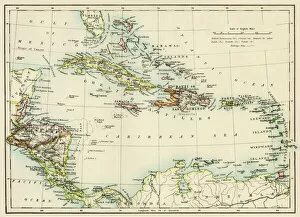
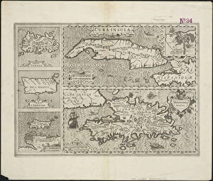
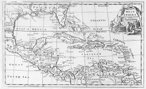
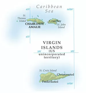
The US Virgin Islands are a group of islands located in the Caribbean Sea, and are part of the Leeward Islands, and consist of three main islands: St
Choose a picture from our Maps Collection for your Wall Art and Photo Gifts
18 items


All Professionally Made to Order for Quick Shipping
-
Maps Collection
The US Virgin Islands are a group of islands located in the Caribbean Sea, and are part of the Leeward Islands, and consist of three main islands: St. Thomas, St. John and St. Croix. The US Virgin Islands have been a US territory since 1917, and their maps reflect this history with its unique blend of American and Caribbean culture. Maps of the US Virgin Islands show its diverse terrain, from lush rainforests to white sand beaches to volcanic mountains; they also show its many small cays, islets and reefs that make up this beautiful archipelago. It also provide information about transportation routes between the islands as well as points of interest such as historical sites, national parks and other attractions for visitors to explore while visiting these beautiful islands in North America.
+
Our beautiful pictures are available as Framed Prints, Photos, Wall Art and Photo Gifts
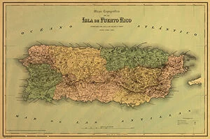
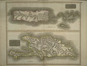
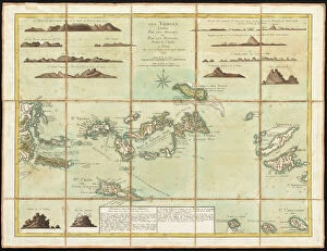
The Maps of US Virgin Islands North America collection is a stunning array of wall art and framed prints that showcase the beauty and diversity of this Caribbean paradise. From vintage maps to modern satellite imagery, these pieces offer a unique perspective on the geography, history, and culture of the islands. Whether you're a traveler looking for inspiration or a collector seeking rare artifacts, there's something for everyone in our collection. Some highlights include detailed topographical maps that highlight the rugged terrain and lush vegetation of St. John, as well as colorful illustrations that capture the vibrant spirit of local festivals like Carnival. Other pieces focus on historical landmarks such as Fort Christiansted or famous beaches like Magens Bay. Our collection offers an unparalleled glimpse into one of North America's most beloved vacation destinations. With its rich history, natural beauty, and diverse cultural heritage, it's no wonder why so many people are drawn to the US Virgin Islands year after year.
+
What are Maps of US Virgin Islands North America art prints?
Maps of US Virgin Islands North America art prints are high-quality reproductions of maps depicting the geography, topography and landmarks of the US Virgin Islands. These art prints showcase the beauty and diversity of this region in North America, including its stunning beaches, lush forests, and vibrant cities. These maps can be used for a variety of purposes such as educational resources for students studying geography or history, decorative pieces for homes or offices that celebrate travel or cultural heritage, or as gifts for those who love to explore new places. The Maps of US Virgin Islands North America art prints come in different sizes and formats to suit individual preferences. They are printed on archival quality paper using state-of-the-art printing technology to ensure they last a lifetime without fading or yellowing. These art prints offer a unique way to appreciate the natural beauty and rich history of the US Virgin Islands while adding an aesthetic touch to any space.
+
What Maps of US Virgin Islands North America art prints can I buy from Media Storehouse?
We offer a wide range of Maps of US Virgin Islands North America art prints that are perfect for decorating your home or office. These maps showcase the beautiful and intricate details of the islands, including their coastlines, landmarks, and topography. You can choose from a variety of styles and sizes to suit your needs, whether you prefer a vintage look or a modern design. Some popular options include antique maps that capture the history and culture of the region, as well as contemporary designs that highlight its natural beauty. You can also select from different materials such as canvas or paper to create the perfect display piece for any room. Whether you're looking to add some color to your walls or simply want to learn more about this fascinating part of North America, we have something for everyone. With high-quality prints at affordable prices, it's easy to find exactly what you need to enhance your decor and inspire your imagination.
+
How do I buy Maps of US Virgin Islands North America art prints?
To buy Maps of US Virgin Islands North America art prints from Media Storehouse, you can browse our extensive collection of maps and select the one that you like. Once you have found the map print that suits your taste, click on it to view its details and choose the size and framing options that best fit your needs. You can then add the map print to your cart and proceed to checkout. During checkout, provide your shipping information and payment details to complete your purchase. We offer a wide range of high-quality art prints featuring different themes, styles, sizes, and framing options. Our collection includes vintage maps as well as contemporary designs created by talented artists from around the world. Whether you are looking for a unique piece of wall decor or a thoughtful gift for someone special, we have something for everyone.
+
How much do Maps of US Virgin Islands North America art prints cost?
The cost of Maps of US Virgin Islands North America art prints may vary depending on the size, quality, and type of print. However, we offer a wide range of options to choose from at competitive prices. These maps are perfect for those who love geography or want to decorate their home or office with unique artwork that showcases the beauty and diversity of North America's landscapes. Whether you prefer vintage-style maps or modern designs, we have something for everyone. The company works with talented artists and photographers to create high-quality prints that capture the essence of each location. While we cannot provide specific pricing information in this answer, we can assure you that Media Storehouse strives to offer affordable options without compromising on quality. So if you're looking for Maps of US Virgin Islands North America art prints, be sure to check out what they have available.
+
How will my Maps of US Virgin Islands North America art prints be delivered to me?
Your Maps of US Virgin Islands North America art prints will be delivered to you in a safe and secure manner. The Media Storehouse takes great care in packaging your artwork so that it arrives at your doorstep undamaged. Your print will be carefully rolled up and placed inside a sturdy cardboard tube for protection during transit. Once the package has been dispatched, you can track its progress using the tracking number provided by the store. This way, you can keep an eye on when your artwork is expected to arrive. When your package does arrive, simply unroll the print and admire it. You may choose to frame it or display it as is - either way, we hope that you enjoy your new piece of art from Media Storehouse.