Home > Maps and Charts > Americas
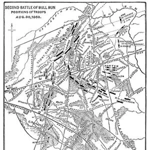
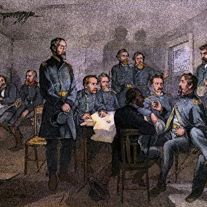
Map of the Second Battle of Bull Run, 1862

![]()
Wall Art and Photo Gifts from North Wind
Map of the Second Battle of Bull Run, 1862
Bull Run battlefield map showing troop positions on August 29, 1862.
Hand-colored woodcut of a 19th-century illustration
North Wind Picture Archives brings history to life with stock images and hand-colored illustrations
Media ID 5879619
© North Wind Picture Archives
1862 America Battle Battle Field Battle Of Bull Run Bull Run Civil War Manassas Rebellion South Southern Virginia Second Battle Of Bull Run
FEATURES IN THESE COLLECTIONS
> North America
> Related Images
> North Wind Picture Archives
> Civil War (US)
> North Wind Picture Archives
> Maps
> South America
> Related Images
EDITORS COMMENTS
This print showcases a hand-colored woodcut of a 19th-century illustration depicting the Map of the Second Battle of Bull Run, which took place in 1862 on the Bull Run battlefield in Virginia. The intricate details and vibrant colors bring to life this historic moment during the Civil War. The map reveals troop positions on August 29, providing valuable insight into the strategic movements that shaped this significant battle between the North and South. As you study each line and symbol, you can almost feel the tension and anticipation that filled the air during those fateful days. This vintage artwork serves as a powerful reminder of America's turbulent past, capturing both its heritage and traditional values. It transports us back to an era when our nation was divided by rebellion, yet united by a common history. As we gaze upon this remarkable piece, we are reminded of the sacrifices made by brave soldiers who fought valiantly for their beliefs. It is through art like this that we can better understand our shared history and appreciate how far we have come as a nation. Whether you are an avid history enthusiast or simply captivated by beautiful illustrations from another time, this print offers a glimpse into one of America's most defining moments – The Second Battle of Bull Run.
MADE IN AUSTRALIA
Safe Shipping with 30 Day Money Back Guarantee
FREE PERSONALISATION*
We are proud to offer a range of customisation features including Personalised Captions, Color Filters and Picture Zoom Tools
SECURE PAYMENTS
We happily accept a wide range of payment options so you can pay for the things you need in the way that is most convenient for you
* Options may vary by product and licensing agreement. Zoomed Pictures can be adjusted in the Cart.