Home > Europe > Netherlands > Maps
EXPL2A-00346

![]()
Wall Art and Photo Gifts from North Wind
EXPL2A-00346
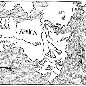
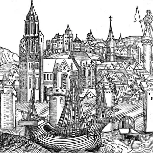
Early map showing Nova Zembla off the Arctic coast of Russia, probably 1600s.
Hand-colored 19th-century woodcut reproduction
North Wind Picture Archives brings history to life with stock images and hand-colored illustrations
Media ID 5881024
© North Wind Picture Archives
1600s 17th Century Adventure Arctic Arctic Ocean Discover Dutch Europe Exploration Explore Ice Berg Journey Netherlands North Sea Ocean Russia Russian Sail Scandinavia Seal Ship Travel Voyage Whale Baltic Baltic Sea Northeast Passage Nova Zembla Novaya Zemlya
FEATURES IN THESE COLLECTIONS
> Europe
> Netherlands
> Maps
> Maps and Charts
> Early Maps
> Maps and Charts
> Netherlands
> North Wind Picture Archives
> European history
> North Wind Picture Archives
> Maps
EDITORS COMMENTS
This print takes us back in time to the 1600s, when exploration and adventure were at their peak. The image showcases an early map depicting Nova Zembla, a remote island off the Arctic coast of Russia. Hand-colored with meticulous detail, this 19th-century woodcut reproduction allows us to appreciate the artistry and craftsmanship of that era. The scene is filled with elements that evoke a sense of wonder and curiosity. A majestic whale gracefully swims through the ocean waters, reminding us of the diverse marine life found in these uncharted territories. In the distance, a sturdy ship sails bravely towards its destination, symbolizing the spirit of discovery and human resilience. As we delve into this historic illustration, we are transported to a time when journeys across vast oceans were both treacherous and awe-inspiring. This map highlights not only Nova Zembla but also other regions such as Scandinavia and parts of Europe's Baltic Sea. It serves as a testament to the explorers who dared to venture into unknown territories in search of new trade routes or scientific knowledge. With its icy landscapes dominated by towering icebergs, this image captures the harsh beauty of the Arctic region. Seals can be seen basking on floating chunks of ice while history unfolds around them. This print from North Wind Picture Archives invites us to embark on our own voyage through time – an opportunity to explore history through art and immerse ourselves in tales from centuries past without leaving our present-day surroundings.
MADE IN AUSTRALIA
Safe Shipping with 30 Day Money Back Guarantee
FREE PERSONALISATION*
We are proud to offer a range of customisation features including Personalised Captions, Color Filters and Picture Zoom Tools
SECURE PAYMENTS
We happily accept a wide range of payment options so you can pay for the things you need in the way that is most convenient for you
* Options may vary by product and licensing agreement. Zoomed Pictures can be adjusted in the Cart.